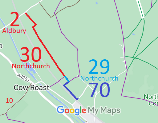
Annotated map reproduced courtesy of Googlemaps.
We need a volunteer to photograph this route for this year's Access and Riding Rights of Way Survey. It's easy - just take photographs (safely) when you use the path. Find out more!
| Paths Greenways Bridleways Tracks | ||
| PG: OBJECTS: PROMOTION: Aldbury 2 RB Northchurch 30 RB, 29, 70 | ||
Annotated map reproduced courtesy of Googlemaps. |
This route starts from Newground Road (public road) as Aldbury 2 restricted byway. It continues southeastwards to the parish boundary where it becomes Northcurch 30 restricted byway. The route then is recorded as bridleways 29 and 70 Northchurch, and ends on Norcott Farm Lane (public road).
We need a volunteer to photograph this route for this year's Access and Riding Rights of Way Survey. It's easy - just take photographs (safely) when you use the path. Find out more! |
| Legal History 20 Jun 1953: Aldbury 2 was recorded as CRB (Carriage Road used as a Bridleway) on the original definitive statement. DM sheet DM3-11 (SP91SE, Herts 25 SE). 31 Dec 1977: Aldbury 2 was shown as a bridleway on the special review draft map and statement, but there were objections and so the route remained as a RUPP. DM sheet SR-52 (SP91SE). 20 Nov 1998: It is reported that the owners dedicated bridleway rights on Aldbury 2 and Northchurch 30. Such dedication cannot remove higher rights already in existence. 2 May 2006: Restricted Byway rights were confirmed or created on Aldbury 2 and Northchurch 30 by virtue of ss 47 and 48 Countryside and Rights of Way Act 2000. ... |
Definitive Statement (4 Dec 2015)
Path: [Aldbury] 2. Status: Restricted Byway. Definitive Map sheet: 52 Commences at junction with county road NE of railway thence SE to parish boundary and towards Norcott Court Farm (Northchurch Parish). (This former RUPP had bridleway rights dedicated over it on 20 November 1998). Width: minimum 3m Statement should refer expressly to Northchurch 30 junction. Path: [Northchurch] 30. Status: Restricted Byway.
Definitive Map sheet: 52 Path: [Northchurch] 29. Status: Bridleway/Footpath.
Definitive Map sheet: 52 Path: [Northchurch] 70. Status: Bridleway.
Definitive Map sheet: 85 |
© 2022 Patchetts Green Bridleways Trust.
