| Paths Greenways Bridleways Tracks | ||
| PG: OBJECTS: PROMOTION: Aldbury 67 | ||
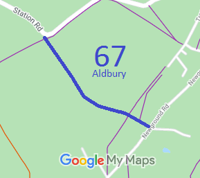
![]() Annotated map reproduced courtesy of Googlemaps. |
This route runs from Station Road (public road) generally southeastwards to Newground Road (public road).
We need a volunteer to photograph this route for this year's Access and Riding Rights of Way Survey. It's easy - just take photographs (safely) when you use the path. Find out more! |
|||
As part of the British Horse Society's work to record paths before
Path Extinguishment Day,
it was spotted that the historical evidence showed a continuous old road, so an application was made in 2015 to record the route as a restricted byway.
| ||||
| Legal History 14 Jun 1999: Landowner deposit by Pendley Farms under s.31(6) Highways Act 1980 states that route has been dedicated as a bridleway. 23 Mar 2015: Application to upgrade from bridleway to restricted byway. HCC reference DAC/146. |
Definitive Statement (4 Dec 2015)
Path: [Aldbury] 67. Recorded Status: Bridleway. Definitive Map sheet: 51 Commences at junction with county road SW of Church Farm and FP63 thence SE to junction with FP68 thence SE from this point to junction with county road opposite Brightwood. |
© 2021 Patchetts Green Bridleways Trust. File reference: EC767A.