Paths Greenways Bridleways Tracks
 PG: OBJECTS: PROMOTION: Sacombe 12 and Bengeo Rural 23 - A602 crossing
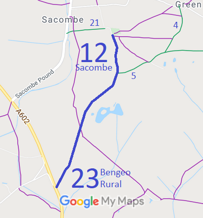
Map showing recorded Sacombe and Bengeo paths
Annotated map reproduced courtesy of Googlemaps.
This page is about the A602 crossing at the southern end of Bengeo Rural 23 bridleway. For the information about the paths either side of the crossing, see Sacombe 12 and Bengeo Rural 23 bridleway and Sacombe 25 and Bengeo Rural 27.

On 21 Jun 2019, Hertfordshire County Council consulted the public and the usual interested parties, including the British Horse Society, about a planned side roads order that would be needed to adjust highways close to the line of the A602. The draft A602 Improvements (Watton-at-Stone to Tonwell) Classified Road (Side Roads) Order 2019 was circulated so that detailed comments could be provided.

The draft provided that where Bridleway Bengeo Rural 23 met the A602 highway, the old C16 Road (southwest from Ware Road past Burns Green Farm to Stoneyhills Southern spur to Ware Road) would be converted to a bridleway such that the link to Stony Hills was maintained.

Various representations were made about crossings and junctions on the A602 proposals, but the county council decided that riders could cross the A602 at grade.

Read the latest information about the changes from the County Council's website.

Legal History
2 Feb 1953: Sacombe 12 was recorded as a bridleway on the original definitive map and statement. The section in Bengeo was not recorded. DM sheet DM2-11.
31 Dec 1977: Sacombe 12 and Bengeo 23 were shown as bridleways on the special review draft map and statement. DM sheet SR-45.
Definitive Statement (4 Dec 2015)
Path: [Sacombe] 12.  Status: Bridleway.  Definitive Map sheet: 45
Commences from parish boundary S of Riding Wood Lodge thence NE past Lodge through Sacombe Park to Sacombebury thence N to county road S of Church.

Path: [Bengeo Rural] 23.  Status: Bridleway.  Definitive Map sheet: 45
Commences from Ware Road, thence NE to parish boundary to connect to BR12 in Sacombe parish.

© 2021 Patchetts Green Bridleways Trust. File reference: ED224 (for A602 crossing).

Stats2