Paths Greenways Bridleways Tracks
 PG: OBJECTS: PROMOTION: Bishop's Stortford 5, 6 and 73 BW and Farnham 20 and 22 BW
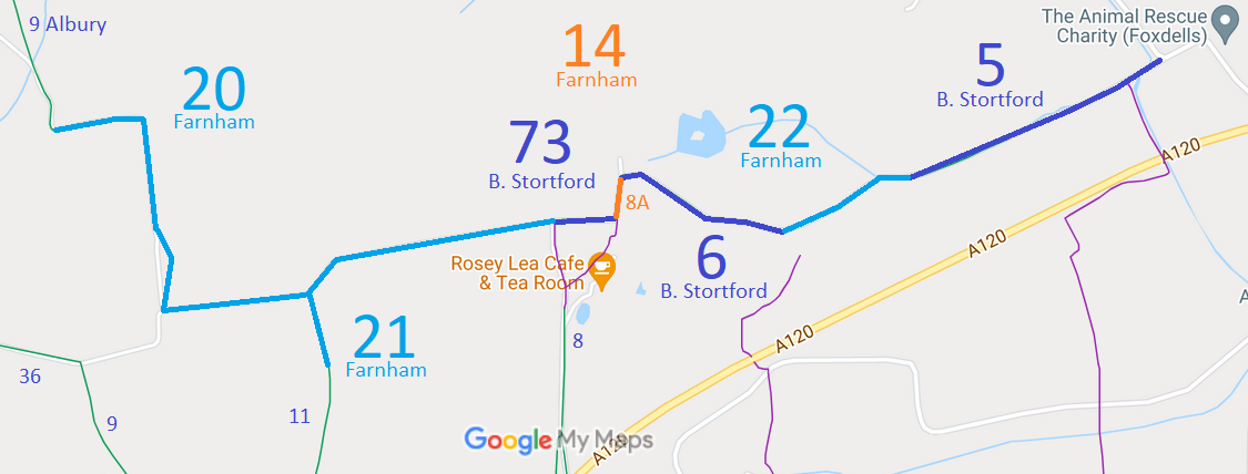
Map showing Bishop's Stortford bridleways by the county boundary
Annotated map reproduced courtesy of Googlemaps.
The numbering of this route looks complicated because is keeps crossing the county boundary! We have shown Hertfordshire paths in dark blue and Essex paths in light blue, so that any problems can be reported to the right authority.

Starting from Albury 9 bridleway at the county boundary, the bridleway continues in Essex as Farnham 20 heading east, south then east again to become Bishop's Stortford 73 in Hertfordshire. After a short distance it heads northwards as bridleway Farnham 14 (also as Bishop's Stortford 8A, shown in orange) then becomes Bishop's Stortford 6, Farnham 22 and finally Bishop's Stortford 5, before ending at Farnham Road (public road).

We need a volunteer to photograph this route for this year's Access and Riding Rights of Way Survey. It's easy - just take photographs (safely) when you use the path. Find out more!

Legal History
The numbering of paths in Bishop's Stortford before 2000 was unlike that in the rest of Hertfordshire!
2 Feb 1953: Bishop's Stortford 5 and 6 were recorded as bridleways P2 and N5 respectively on the original definitive map and statement. DM sheet DM1-20.
2 Feb 1953: Bishop's Stortford 8A was recorded as footpath N1 on the original definitive map and statement. DM sheet DM1-20.
2 Feb 1953: Bishop's Stortford 73 was not recorded on the original Hertfordshire definitive map and statement because at that time, it was entirely within Essex.
31 Dec 1977: Bishop's Stortford 5 and 6 were recorded as bridleways P2 and N5, and Bishop's Stortford 8A was shown as footpath N1 on the special review draft map and statement. DM sheet SR-34.
Hertfordshire Definitive Statement (4 Dec 2015)
Path: [Bishop's Stortford] 5.  Status: Bridleway.  Definitive Map sheets: 34 and 48 Note the reference to sheet 48 seems to be an error
Commences at county boundary at Bourne Brook thence SW along said boundary to join BR22 in Essex.

Path: [Bishop's Stortford] 6.  Status: Bridleway.  Definitive Map sheet: 34
Connecting FP1 to BR8 From county and district boundary (continuation of BR22 in Essex) west along boundary to join BR8.

Path: [Bishop's Stortford] 73.  Status: Bridleway.  Definitive Map sheet: 34
From its junction with FP8a N of Wickham Hall in a westerly direction to the County Boundary and junction with BR20 (Farnham, Essex)

Essex Definitive Statement (Working copy, taken 4 Jun 21)
Path: [Farnham] 22.  Status: Bridleway.  Definitive Map sheets: 42 SE
From its junction with BR14 in an easterly direction to the parish and County boundary with Hertfordshire.

Path: [Farnham] 20.  Status: Bridleway.  Definitive Map sheets: 42 SE
From its junction with BR14 at Wickham Hall in a westerly, northerly and westerly direction to the parish and County boundary of Hertfordshire at Moorfield Spring

Path: [Farnham] 14.  Status: Bridleway.  Definitive Map sheets: 42 SE
From Bridleway 20 leading north-easterly passing Bridleway 22 and 13 before turning north-westerly for approximately 550 metres. This section has unspecified width. Then along the headland on the southern perimeter of Bailey Hills wood north-westerly to the south western tip of Bailey Hill wood passing through an existing gap to continue north-westerly along a farm track for approximately 264 metres. This section is 3 metres wide. Then north-westerly and north-easterly then easterly to the parish and County boundary. This section is unspecified in width.
© 2022 Patchetts Green Bridleways Trust.

Stats2