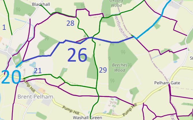
Map data from © OpenStreetMap, Hertfordshire County Council and Essex County Council.
A volunteer has photographed this route for the 2023 Access and Riding Rights of Way Survey, and the page will be updated shortly. Find out more!
| Paths Greenways Bridleways Tracks | ||
| PG: OBJECTS: PROMOTION: Brent Pelham and Meesden 20 and 26 and Clavering (Essex) 31 | ||
Map data from © OpenStreetMap, Hertfordshire County Council and Essex County Council. |
This page is still being prepared.
A volunteer has photographed this route for the 2023 Access and Riding Rights of Way Survey, and the page will be updated shortly. Find out more! |
| Legal History 2 Feb 1953: Brent Pelham 3 was recorded as a footpath on the original definitive map and statement. DM sheet DM1-05 (Herts 9 SE). When the parishes joined, the path was renumbered as Brent Pelham and Meesden 20. 31 Dec 1977: The route was shown as part bridleway and part footpath on the special review draft map and statement. DM sheet SR-16 (TL43SE). |
Definitive Statement (4 Dec 2015)
Path: [Brent Pelham and Meesden] 20. Status: Bridleway/Footpath. Definitive Map sheet: 16 Commences from The Lane by Brent Pelham Hall Kitchen Garden NE across the Park (Silver Leys) thence along the bottom of an arable field to Blackhall thence E parallel to BR28 (to TL 4410 3163) thence northwards for approx 100m to the SW corner of Parish Acre (TL 4411 3173), eastwards on the south side of the hedge for approx 120m to the boundary between the parish of Brent Pelham and the parish of Meesden (TL 4423 3174) continuing SE and S to the SW side of the hedge for approx 120m along the parish boundary between Brent Pelham and Meesden to the corner of the field (TL 4429 3165) continuing E on the S side of the hedge for approx 190m to Oxbury Wood (at TL 4447 3168) thence S on the W side of the hedge for approx 60m to junction with BR29 at SW corner of Oxbury Wood (TL 4448 3162). Path: [Brent Pelham and Meesden] 26. Status: Bridleway.
Definitive Map sheet: 16 Statement could usefully refer to the junction with the bridleway in Essex at the county boundary. |
© 2023 Patchetts Green Bridleways Trust.