| Paths Greenways Bridleways Tracks | ||
| PG: OBJECTS: PROMOTION: Buckland 1 BW | ||
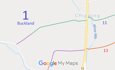
![]() Annotated map reproduced courtesy of Googlemaps. |
This route starts on the A10, not far from Buckland 11 bridleway, and heads generally south westwards to Sandon Lane (public road). | |||
As part of the British Horse Society's work to record paths before
Path Extinguishment Day,
it was spotted that Buntingford 1 did not appear to reach the road on today's definitive map. The first definitive map showed a continuous bridleway route, so an application was made in 2021 to record the gap. As a back up to the documentary evidence, we are now collecting user statements.
| ||||
| If you have ridden the route, please download a user evidence form and then follow the instructions and return the form to us. It only takes a few minutes to fill in (the whole form fits on one side of a piece of A4 paper). If you have any other questions, please email us. | ||||
| Legal History 2 Feb 1953: Buckland 1 was recorded as a bridleway on the original definitive map and statement. DM sheet DM1-02. 31 Dec 1977: Buckland 1 was recorded as a bridleway on the special review draft map and statement. DM sheets SR-14 and SR-15. Buckland 1 is recorded as part FP part BW on the 2005 definitive map, and BW in the definitive statement. This looks like an error. 6 Feb 2021: Application made to record route as bridleway. HCC reference EH/502. |
Definitive Statement (4 Dec 2015)
Path: [Buckland] 1. Status: Bridleway. Definitive Map sheets: 14, 15 Commences at junction with Royston Road (A10) by Popes Hall at Chipping thence SW past Mill Hill to junction with county road. |
© 2022 Patchetts Green Bridleways Trust. File reference: EC902. HCC reference: EH/502/MOD.