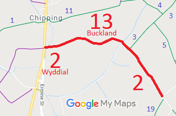
Annotated map reproduced courtesy of Googlemaps.
We need a volunteer to photograph this route for this year's Access and Riding Rights of Way Survey. It's easy - just take photographs (safely) when you use the path. Find out more!
| Paths Greenways Bridleways Tracks | ||
| PG: OBJECTS: PROMOTION: Buckland 13 RB and Wyddial 2 RB | ||
Annotated map reproduced courtesy of Googlemaps. |
This route runs from Royston Road along the parish boundary as both Buckland 13 and Wyddial 2. It leaves the parish boundary as Wyddial 2 and continues generally southsouth eastwards to Brown's Corner (on the public road).
We need a volunteer to photograph this route for this year's Access and Riding Rights of Way Survey. It's easy - just take photographs (safely) when you use the path. Find out more! |
| Legal History 1840: The eastern part of Wyddial 2 was shown on the Wyddial tithe map as not subject to an apportionment. 1844: The western part of Buckland 13 was shown on the Buckland tithe map (before passing into Laystone parish) as not subject to an apportionment. 2 Feb 1953: Buckland 13 and Wyddial 2 were recorded as CRBs (Carriage Roads used as Bridleways) on the original definitive map and statement. DM sheets DM1-02 and DM1-04. 31 Dec 1977: The route was proposed to be downgraded to bridleway in the special review draft map and statement, but this was not taken forwards. DM sheet 15. Restricted Byway rights were confirmed or created on this path by virtue of ss 47 and 48 Countryside and Rights of Way Act 2000 on 2 May 2006. |
Definitive Statement (4 Dec 2015)
Path: [Buckland] 13. Status: Restricted Byway. Definitive Map sheet: 15 Commences at junction with Royston Road S of Popes Hall thence E along Green Lane to parish boundary. Path: [Wyddial] 2. Status: Restricted Byway.
Definitive Map sheet: 15 |
© 2024 Patchetts Green Bridleways Trust.
