Paths Greenways Bridleways Tracks
 PG: OBJECTS: PROMOTION: Buntingford 13
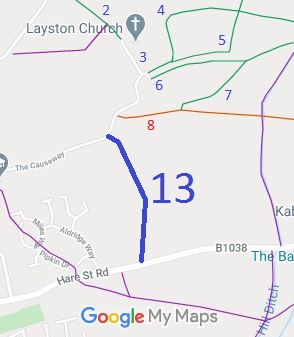
Map showing Buntingford 13
Annotated map reproduced courtesy of Googlemaps.
Buntingford 13 runs from The Causeway (public road) generally southwards to Hare Street Road (B1038 public road).

We need a volunteer to photograph this route for this year's Access and Riding Rights of Way Survey. It's easy - just take photographs (safely) when you use the path. Find out more!

BHSAs part of the British Horse Society's work to record paths before Path Extinguishment Day, it was spotted that Buntingford 13 appears to have unrecorded restricted byway rights. An application was made in 2019 to upgrade the bridleway to restricted byway, based on the historical evidence so that these rights are not extinguished by the Countryside and Rights of Way Act 2000 on Path Extinguishment Day.

Legal History
2 Feb 1953: Buntingford 13 was recorded as a bridleway on the original definitive map and statement. DM sheet DM1-10 (Herts 14 NW).
31 Dec 1977: Buntingford 13 was shown as a bridleway on the special review draft map and statement. DM sheet SR-24 (TL32NE).
22 Jul 2019: Application made to upgrade to restricted byway.
Application Process
Path Application Certificate Direction Inv Report Order Confirmed
EC1072 22 Jul 2019 EH/479 4 Sep 2019        
Definitive Statement (4 Dec 2015)
Path: [Buntingford] 13.  Status: Bridleway.  Definitive Map sheet: 24
Commences from the causeway SW of Layston Church then S to meet the Hare Street Road near Mill Cottages.
Maintainability
This route is maintainable at the public expense because it was a footpath or bridleway existing before 30 Apr 1959.

© 2024 Patchetts Green Bridleways Trust. File reference: EC1072. HCC reference: EH/479.

Stats2