
Annotated map reproduced courtesy of Googlemaps.
At the time of the BHS 2021 Access Survey (23 Sep 21), no gates were across the path and it was signposted at each end. There has been a marked increase in bollards and barriers since the dedication, and we are investigating the legality of so many obstructions.

Looking northwest along Bushey 56
Photo: Phil Wadey, 27 Jan 2007

1. Sign at Otterspool Lane
Photo: Michael Rackham, 23 Sep 2021
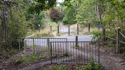
2. View from Otterspool Lane
Photo: Michael Rackham, 23 Sep 2021

3. Looking southeast along Bushey 56
Photo: Michael Rackham, 23 Sep 2021

4. View from Bushey Grove Lane
Photo: Michael Rackham, 23 Sep 2021

5. Sign at Bushey Grove Lane
Photo: Michael Rackham, 23 Sep 2021


 This route was constructed when the M1 motorway was built, but was not recorded on the definitive
map at the time when the Patchetts Green Riding Club performed the ARROW survey for the British
Horse Society in 1991.
An approach was made to the landowners, the (then) Department of Transport, and they agreed to execute a deed of dedication to enable the path to be recorded. A special acknowledgement is due to the Bushey and District Footpaths Association for their work towards the recording of this bridleway. Their chairman, Chris Beney, helped with the surveying of the path, and the adjacent footpath, so that the deed of dedication could be drawn up accurately.
