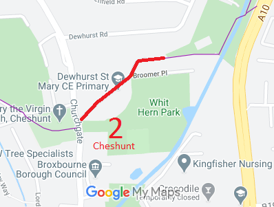
Annotated map reproduced courtesy of Googlemaps.
We need a volunteer to photograph this route for this year's Access and Riding Rights of Way Survey. It's easy - just take photographs (safely) when you use the path. Find out more!
| Paths Greenways Bridleways Tracks | ||
| PG: OBJECTS: PROMOTION: Cheshunt 2 RB Churchfield Path | ||
Annotated map reproduced courtesy of Googlemaps. |
This route starts on Churchgate Road (public road) then heads generally northeastwards to a junction with Footpath 2. There is a barrier at the junction, so horse riders will not be able to proceed. The whole of the restricted byway has the appearance of an ordinary residential street.
We need a volunteer to photograph this route for this year's Access and Riding Rights of Way Survey. It's easy - just take photographs (safely) when you use the path. Find out more! |
| Legal History 2 Feb 1953: Cheshunt 2 RB was shown as CRF (Carriage Road used as a Footpath) on the original definitive map and statement. DM sheet DM2-37. 3 May 1968: The Urban District Council of Cheshunt Churchfield Path, Cheshunt, Public Path No. 2 (Part) Diversion Order, 1968 (confirmed 24 Oct 1968) diverted the footpath. HCC reference DM2/100. 31 Dec 1977: The route was shown as part byway and part footpath on the special review draft map and statement. DM sheets SR-80 (TL30SW) and SR-81 (TL30SE). There must have been objections to the byway section as this remained shown as a RUPP on the consolidated map. 2 May 2006: Restricted Byway rights were confirmed or created on this path by virtue of ss 47 and 48 Countryside and Rights of Way Act 2000. |
Definitive Statement (4 Dec 2015)
Path: [Cheshunt] 2. Status: Restricted Byway/Footpath. Definitive Map sheets: 80, 81 Commences opposite St Mary's Church then in a northeast direction to join with FP3. From FP3 at River bridge northeast for approx. 278 feet along boundary along side western bank of New River, 8ft 6" wide, to Churchfield Path over bridge over New River, across Gt Cambridge Road thence to Church Lane. |
© 2024 Patchetts Green Bridleways Trust.
