
- Chipperfield 11 BW, from Stoney Lane to the Chipperfield to Bovingdon road.
- Chipperfield Common riding routes

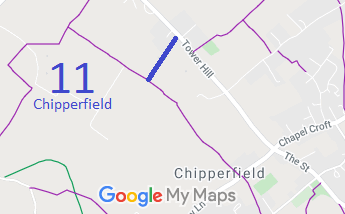

Annotated maps reproduced courtesy of Googlemaps.


 Local Government: Formerly within Hemel Hempstead Rural District.
From 1974, part of Dacorum District.
The Parish Council was formed in 1958 by being separated from the administrative parish of Kings Langley.
Tithe (1835) DSA4/64/2 (Kings Langley) (fully checked for evidence, one application assisted).
