Paths Greenways Bridleways Tracks
 PG: OBJECTS: PROMOTION: Cottered 35
We're collecting user evidence for the council now: Download user evidence form - Read the Instructions
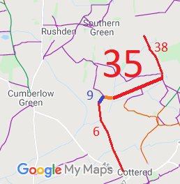
Map showing Cottered 35
Annotated map reproduced courtesy of Googlemaps.
This route starts from Cottered 38 restricted byway and heads east south east to Rushden and Wallington 9 bridleway (shown in blue).

A volunteer has photographed this route for the Access and Riding Rights of Way Survey, and the page will be updated shortly. Find out more!

BHS PGBTAs part of the British Horse Society's work to record paths before Path Extinguishment Day, it was spotted that a short section of Cottered 35 (shown in orange) is only recorded as a footpath when it is the only link between Cottered 35 restricted byway and Rushden and Wallington 9 bridleway. The British Horse Society is collecting user evidence for people who ride this short path to make sure that it is maintained as a through route for riders.
If you have ridden the orange route, please download a user evidence form and then follow the instructions and return the form to us. It only takes a few minutes to fill in (the whole form fits on one side of a piece of A4 paper). If you have any other questions, please email us.

Legal History
2 Feb 1953: Broadfield 2 was recorded as part footpath and part CRB (Carriage Road used as a Bridleway) on the original definitive map and statement. DM sheet DM1-02 (Herts 8 SE).
2 Feb 1953: Broadfield 3 was recorded as CRF (Carriage Road used as a Footpath) on the original definitive statement. DM sheet DM1-02 (Herts 8 SE).
1 Apr 1955: Broadfield parish was incorporated into Cottered parish by The County of Hertford (Parish of Cottered) Confirmation Order 1955.
1 Apr 1955: Broadfield 2 and 3 were renumbered as Cottered 35.
31 Dec 1977: Cottered 35 was shown as a bridleway on the special review draft map and statement, but there must have been an objection as it remained recorded as part RUPP part FP. DM sheet SR-14 (TL33SW).
2 May 2006: Restricted Byway rights were confirmed or created on the previous RUPP part by virtue of ss 47 and 48 Countryside and Rights of Way Act 2000.
Definitive Statement (4 Dec 2015)
Path: [Cottered] 35.  Status: Restricted Byway.  Definitive Map sheet: 14
Commences at Rushden parish boundary thence E to cart-bridge over stream, thence NE to field-gate and junction with FP3 thence continuing NE to junction with Restricted Byway 38 W of Broadfield Hall.

© 2024 Patchetts Green Bridleways Trust. File reference: EC903.