Legal History
20 Jun 1953: The route was not recorded on the original definitive map and statement.
DM sheet DM3-05 (TL01NE).
31 Dec 1977: The route was not shown on the special review draft map and statement.
DM sheet SR-40 (TL01NE).
23 Mar 2013: Application to record as a restricted byway.
3 Aug 2018: The Hertfordshire County Council (Markyate 25 and Flamstead 58) Modification Order 2018 was made. If confirmed unaltered it will record the route as a restricted byway.
5 Mar 2024: The Stile reports that the County Council submitted the order to the Secretary of State for confirmation.
14 Jan 2025: The Planning Inspectorate consulted about the process to be applied (inquiry, hearing, written representations). PINS reference: ROW/3340076. (Replied WR on 21 Jan 25.)
2 Sep 2025: Order confirmed at restricted byway status. (Advertised 22 Oct 2025.)
|
| Application Process |
| Path |
Application |
Certificate |
Direction |
Inv Report |
Order |
Confirmed |
| EC799 |
23 Mar 2013 DAC/135 |
20 Mar 2014 |
Not needed |
19 Feb 2018 |
3 Aug 2018 |
2 Sep 2025 |
| Inquiry Timetable - ROW/3340076 |
| Path |
Start Date |
OMA SOC |
Other SOCs |
Comments 1 |
Comments 2 |
Result |
| EC799 |
18 Mar 2025 |
1 Apr 2025 |
13 May 2025 |
24 Jun 2025 |
N/A |
2 Sep 2025 |
|
Definitive Statement (14 Jun 2018)
Path: [Markyate] 25. Status: Restricted Byway.
Definitive Map sheet: 40
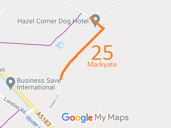
Commences from Green Lane at TL 0697 1609 and runs along the same lane and parish boundary generally NE for approx 440m to TL 0723 1643 then NW for approx 95m to join Windmill Road at TL 0716 1649.
Width: Varies between 10m and 26m between TL 0697 1609 and TL 0716 1649 as shown in the Hertfordshire County Council (Markyate 25 and Flamstead 58) Modification Order 2018 and includes the Flamstead moiety of the route as shown in the Order.
Limitations: None.
Path: [Flamstead] 58. Status: Restricted Byway.
Definitive Map sheet: 40
Commences from Green Lane at TL 0697 1609 and runs along the same lane and parish boundary generally NE for approx 440m to TL 0723 1643 then NW for approx 95m to join Windmill Road at TL 0716 1649.
Width: Varies between 10m and 26m between TL 0697 1609 and TL 0716 1649 as shown in the Hertfordshire County Council (Markyate 25 and Flamstead 58) Modification Order 2018 and includes the Markyate moiety of the route as shown in the Order.
Limitations: None.
|
Maintainability
This route is maintainable at the public expense because it was a highway before 1835.
|
|

 As part of the British Horse Society's work to record paths before
Path Extinguishment Day,
it was spotted that this unmetalled route was in use by riders but not on the definitive map. An application was made in 2013 to record it.
The County Council agreed with the application and an order was made in 2016.
There were objections and so the Order had to be considered by an inspector appointed by the Secretary of State. The inspector agreed that the statutory tests had been met and confirmed the order.
This is a good example of 'perfectly obvious paths' that could have been extinguished by the Countryside and Rights of Way Act 2000 had an application not been made in time.
