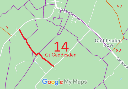
Annotated map reproduced courtesy of Googlemaps.
We need a volunteer to photograph this route for this year's Access and Riding Rights of Way Survey. It's easy - just take photographs (safely) when you use the path. Find out more!
| Paths Greenways Bridleways Tracks | ||
| PG: OBJECTS: PROMOTION: Great Gaddesden 14 RB | ||
Annotated map reproduced courtesy of Googlemaps. |
This route runs from Bradden Lane (not far from Great Gaddesden 5 restricted byway) to Ledgemore Lane.
We need a volunteer to photograph this route for this year's Access and Riding Rights of Way Survey. It's easy - just take photographs (safely) when you use the path. Find out more! |
| Legal History 20 Jun 1953: The route was recorded as CRF (Carriage Road used as a Footpath) on the original definitive map and statement. DM sheet DM3-12. 31 Dec 1977: The route was shown as a footpath on the special review draft map and statement. DM sheet SR-53. Objections stopped this change happening. 2 May 2006: Restricted Byway rights were confirmed or created on this path by virtue of ss 47 and 48 Countryside and Rights of Way Act 2000. 10 Oct 2008: The Hertfordshire County Council (Great Gaddesden 14) Public Path Diversion Order 2008 (confirmed 19 Jul 2010) diverted the ends of this route. HCC reference DAC/77. |
Definitive Statement (4 Dec 2015)
Path: [Great Gaddesden] 14. Status: Restricted Byway. Definitive Map sheet: 53 Commences from Bradden Lane, opposite Widmore Farm at TL 0331 1331 and runs SE for approx. 240m to FP81 at TL 0345 1312, past the junctions with FP15 and then FP16 at TL 0356 1293. Continues along the W side of the boundary hedge to the junction with FP80 at TL 0365 1285 where it turns NE and runs for approx. 50m to the junction with Footpath 13 at TL 0368 1289 and then runs SE along the eastern side of the field boundary for approx. 360m to Ledgemore Lane at TL 0395 1265, opposite Ledgemore Farm. Width: 4m between TL 0331 1331 and TL 0345 1312 4m between TL 0356 1293 and TL 0395 1265 Limitations:None between TL 0331 1331 and TL 0345 1312 None between TL 0356 1293 and TL 0395 1265 |
© 2022 Patchetts Green Bridleways Trust.
File reference: EC252 (for diversion)
