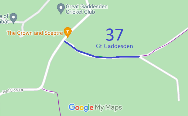
Annotated map reproduced courtesy of Googlemaps.
We need a volunteer to photograph this route for this year's Access and Riding Rights of Way Survey. It's easy - just take photographs (safely) when you use the path. Find out more!
| Paths Greenways Bridleways Tracks | ||
| PG: OBJECTS: PROMOTION: Great Gaddesden 37 | ||
Annotated map reproduced courtesy of Googlemaps. |
This route starts on Red Lion Lane (public road) near The Crown and Sceptre pub and runs generally eastwards to a junction with Great Gaddesden 35 footpath.
We need a volunteer to photograph this route for this year's Access and Riding Rights of Way Survey. It's easy - just take photographs (safely) when you use the path. Find out more! |
| Legal History 20 Jun 1953: Great Gaddesden 37 was shown as a bridleway on the original definitive map and statement. DM sheet DM3-12. 31 Dec 1977: Great Gaddesden 37 was shown as a footpath on the special review draft map and statement, but objections were received and it remained a bridleway. DM sheet SR-53. 2 Nov 1995: Objected-to changes on the Special Review map had to be investigated subsequently. The landowner had requested a downgrade to FP. The county council decided that the route should be shown as a byway and the Hertfordshire County Council (Great Gaddesden 35 & 37) Modification Order 1995 was made. Following a public inquiry, the inspector did not confirm the order. As a result the route remained recorded as a bridleway. HCC Reference DAC/48. PINS reference FPS/M1900/7/6. |
Definitive Statement (4 Dec 2015)
Path: [Great Gaddesden] 37. Status: Bridleway. Definitive Map sheet: 53 Commences at junction with county road by "The Crown and Sceptre" P.H. SW of Bridens Camp thence generally E to junction with FP35 S of Bridens Camp and Big Wood. |
© 2022 Patchetts Green Bridleways Trust.
File reference: EC054.
