Legal History
Most of this route was not recorded on the original (1953) definitive map. The southernmost section was recorded as part of Footpath Kelshall 19.
28 Jun 2010: Application to record the old road as a restricted byway. HCC reference NH/218.
31 Jan 2019: Hertfordshire County Council directed to determine the application by the Secretary of State. (FPS/M1900/14D/18)
17 Feb 2022: The Hertfordshire County Council (Kelshall 18, 19, 21 and 22) Modification Order 2022 (confirmed 18 Dec 2024) added the route to the definitive map and statement as a bridleway.
|
| Application Process |
| Path |
Application |
Certificate |
Direction |
Inv Report |
Order |
Confirmed |
| EC562 |
28 Jun 2010 NH/218 |
16 Nov 2010 |
31 Jan 2019 (12m) |
8 Dec 2020 |
17 Feb 2022 |
18 Dec 2024 |
| Inquiry Timetable - ROW/3320533 |
| Path |
Start Date |
OMA SOC |
Other SOCs |
POEs |
Inquiry |
Result |
| EC562 |
5 Jun 2024 |
31 Jul 2024 |
11 Sep 2024 |
8 Oct 2024 |
5 & 28 Nov 2024 |
18 Dec 2024 |
|
Definitive Statement (1 Jan 2022)
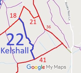
Path: [Kelshall] 22. Status: Bridleway.
Definitive Map sheets: 7 and 14
Commences from Kelshall BOAT 18 (Keepers Lane) at TL 3325 3574 then SSE for approx 685m to E corner of a small wood and junction with Kelshall FP 19 at TL 3354 3517 then SSW on SE side of the small wood for approx 85m to TL 3351 3510, then SSE on E side of the field boundary for approx 185m to cross a stream and join Therfield BOAT 41 at the parish boundary at TL 3358 3494.
Width: Varies between 2.5m and 35m between TL 3325 3574 and TL 3358 3494 as shaded grey in the Hertfordshire County Council (Kelshall 18, 19, 21 and 22) Modification Order 2022.
Limitations: None
|
Maintainability
This route is maintainable at the public expense because it was a highway before 1835.
|
|
 As part of the British Horse Society's work to record paths before
Path Extinguishment Day,
the historic evidence for highways is being worked through and applications are being made where routes appear to exist legally that are not recorded on the definitive map today. This route was applied for in 2010 as a restricted byway. The County Council decided to make an order at bridleway status in 2022, and after the public inquiry into objections the inspector confirmed the status after saying that it was a finely balanced decision.
