Paths Greenways Bridleways Tracks
 PG: OBJECTS: PROMOTION: Letchworth 45 BW
Icknield Way (Hertfordshire East section): To the Ridgeway: Ickleford 18 byway. To the Peddars Way: Icknield Way, Green Lane, Blackhorse Road, Letchworth GRN24.  IWRR 
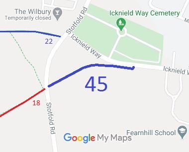
Map showing Letchworth 45 bridleway
Annotated map reproduced courtesy of Googlemaps.
This route runs from the Stotfold Road opposite Ickleford 18 restricted byway to a point on the Icknield Way public road.
BHSWhen the County Council was processing a user evidence based application for a 1.5m wide footpath, the British Horse Society's Regional Access and Bridleways Officer, Alison Balfour-Lynn, spotted that this route was ridden. She informed the council of this, spoke directly to the landowner (the Letchworth Garden City Heritage Foundation) and a dedication was made for a 4m wide bridleway. This is another good example of why consultations with 'footpath' in the title need to be scrutinised just as much as those saying 'bridleway'!

Legal History
Not recorded on the original (1953) definitive map.
7 Nov 2009: Application for footpath. (HCC reference NH/206)
3 May 2013: The Wilbury Hill Public Path Creation Agreement 2013 was made between the Hertfordshire County Council and the Letchworth Garden City Heritage Foundation, enabling the bridleway to be recorded.
Definitive Statement (4 Dec 2015)
Path: [Letchworth Garden City] 45.  Status: Bridleway.  Definitive Map sheet: 12
Commences at Stotfold Road at TL 2006 3249 running generally NE then E along the N boundary of the field for approx 270m to the field corner then continuing generally N for approx 5m through the hedge to meet Icknield Way (town road) at TL 2031 3254
Width: 4m
Limitations: None

© 2023 Patchetts Green Bridleways Trust. File reference: EC655.