Legal History
20 Jun 1953: The route was recorded as a footpath on the original definitive map and statement.
DM sheet DM3-05 (TL01NE).
31 Dec 1977: The route was shown as a footpath on the special review draft map and statement.
DM sheet SR-40 (TL01NE).
1 Mar 2019: Application made to upgrade to bridleway. HCC reference DAC/162.
24 Aug 2024: Application made to the Secretary of State for a direction that Hertfordshire County Council determine the application by a set date. PINS reference ROW/3351113.
11 Nov 2024: Secretary of State directed Hertfordshire County Council to determine the application by 11 May 2025. PINS reference ROW/3351113.
|
| Application Process |
| Path |
Application |
Certificate |
Direction |
Inv Report |
Order |
Confirmed |
| EC1044 |
1 Mar 2019 DAC/162 |
31 May 2019 |
11 Nov 2024 (6mo) |
|
|
|
|
Definitive Statement (4 Dec 2015)
Path: [Markyate] 9. Recorded Status: Footpath.
Definitive Map sheet: 40
Commences at junction with A5 between Red Cow Farm and New Lodge thence NE skirting
NW boundary of Markyatecell Park thence NE to junction with county road W of Hill Farm.
|
Maintenance
This route is maintainable at the public expense because it was a footpath or bridleway existing before 30 Apr 1959.
|
|
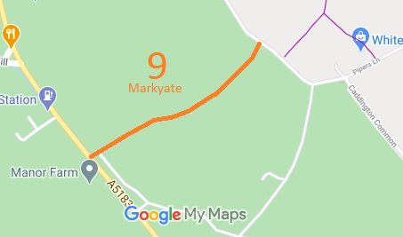
 As part of the British Horse Society's work to record paths before
Path Extinguishment Day,
it was spotted that this path had been set out as a bridleway in the Caddington Inclosure Award. An application was made in 2019 to record the route as a bridleway.
