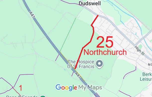
Annotated map reproduced courtesy of Googlemaps.
We need a volunteer to photograph this route for this year’s Access and Riding Rights of Way Survey. It's easy - just take photographs (safely) when you use the path. Find out more!
| Paths Greenways Bridleways Tracks | ||
| PG: OBJECTS: PROMOTION: Northchurch 25 BOAT - Pea Lane | ||
Annotated map reproduced courtesy of Googlemaps. |
This byway runs from the route next to the A41 bypass to Tring Road (public road).
We need a volunteer to photograph this route for this year’s Access and Riding Rights of Way Survey. It's easy - just take photographs (safely) when you use the path. Find out more! |
| Legal History 20 Jun 1953: The route was recorded as CRB (Carriage Road used as a Bridleway) on the original definitive statement. DM sheet DM3-19 (Herts 32 NE; SP90NE). 31 Dec 1977: The route was shown as a byway open to all traffic on the special review draft map and statement. DM sheet SR-64. 13 Oct 2000: The Hertfordshire County Council (A41 Berkhamsted and Kings Langley Bypasses) Legal Event Modification Order 2000 recorded the change to this route caused by the A41 works orders. |
Definitive Statement (4 Dec 2015)
Path: [Northchurch] 25. Status: Bridleway. Definitive Map sheet: 64 Commences at junction with vehicular highway at the NE boundary of the A41 (SP 9630 0842) thence generally NE along Pea Lane to junction with county road (Tring Road A4251). |
© 2026 Patchetts Green Bridleways Trust.