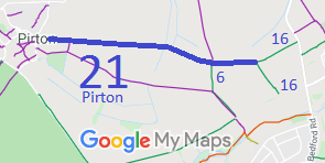
Annotated map reproduced courtesy of Googlemaps.
We need a volunteer to photograph this route for this year's Access and Riding Rights of Way Survey. It's easy - just take photographs (safely) when you use the path. Find out more!
| Paths Greenways Bridleways Tracks | ||
| PG: OBJECTS: PROMOTION: Pirton 21 | ||
| Icknield Way (Hertfordshire East section): To the Ridgeway: Pirton 8. To the Peddars Way: Ickleford 16 bridleway. | IWRR | |
Annotated map reproduced courtesy of Googlemaps. |
This bridleway runs from Little Green, Pirton to
Ickleford 16 bridleway.
We need a volunteer to photograph this route for this year's Access and Riding Rights of Way Survey. It's easy - just take photographs (safely) when you use the path. Find out more! |
| Legal History 1938: The route is shown as a green lane (green dots) on the Hertfordshire County Council ROW survey. Maps Hitchin Rural West 4 (Herts 6 SE) and 5 (Herts 7 SW). 1 Nov 1953: The route was not recorded on the original definitive map and statement. DM sheet DM4-14 (Herts 6 SE) and DM4-17 (Herts 7 SW). 31 Dec 1977: The route was shown as a bridleway on the special review draft map and statement but objections were made. DM sheet SR-11 (TL13SE). 23 Nov 1995: The Hertfordshire County Council (Pirton 21) Modification Order 1995 (confirmed 7 Oct 1997) added this route to the definitive map and statement as a bridleway. |
Definitive Statement (4 Dec 2015)
Path: [Pirton] 21. Status: Bridleway. Definitive Map sheet: 11 Commences from a point 200m east of the County Road at Little Green, Pirton, thence eastwards for about 140m to the junction with FP13, continuing eastwards for approx 1570m to the junction with BR6 and FP6 and thence still eastwards for about 480m to a junction with BR16 (Ickleford) on the parish boundary. Width: 7m to 14m as shown by the hatching on the plan annexed to the Hertfordshire County Council Pirton 21 Modification Order. Statement should record precise name of the 1995 order (by adding the year), to aid tracing in several years' time. |
© 2024 Patchetts Green Bridleways Trust. File reference: EC022.