Paths Greenways Bridleways Tracks
 PG: OBJECTS: PROMOTION: Rickmansworth 18 and 19 BW, Chorleywood 25 BW
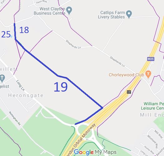
Map showing Rickmansworth 18 & 19 bridleway
Annotated map reproduced courtesy of Googlemaps.
This route runs from Stag Lane (public road) towards M25 motorway, then along the boundary of the M25 to Long Lane (public road), almost opposite Rickmansworth 10 BW. The most northerly piece, Rickmansworth 18, runs along the parish boundary so also has a number (25) in Chorleywood.

If you ride Rickmansworth 19, you might also ride this route for which we are collecting user evidence.
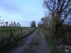
Rickmansworth 19 near M25

Route parallel to Motorway
Photo: Phil Wadey, 11 Apr 2017

BHS This route was identified as in use and not recorded on the definitive map. A British Horse Society volunteer collected user evidence to demonstrate that the route was a bridleway. The County Council agreed with the application and an order was made in 2017 and confirmed unopposed.

Legal History
20 Jun 1953: Recorded as footpaths on the original definitive map.
9 Feb 1973: The London North Orbital Trunk Road (Hunton Bridge to Maple Cross Section Side Roads) Order 1973 set out the southern section of Rickmansworth 19 FP.
31 Dec 1977: Rickmansworth 18 & 19 were shown as footpaths on the special review draft map and statement. DM sheets SR-82 (TQ09NW) and SR-88 (TQ09SW).
28 Mar 2017: Application for BW status on the basis of long usage. HCC reference 3R/99.
29 Sep 2017: The Hertfordshire County Council (Chorleywood 25, Rickmansworth 18 and 19) Modification Order 2017 was made. It was confirmed on 9 Mar 2018, so adding the bridleway rights to the definitive map and statement.
Definitive Statement (14 Sep 2017)
Path: [Chorleywood] 25.  Status: FP/BR.  Definitive Map sheet: 82
Commences as a FP at a junction with FPs at Urban District Boundary S of Hill Farm N to a junction with Rickmansworth BR 19 at TQ 0248 9508. Continuing N as a BR to a junction with Stag Lane at TQ 0247 9523. Then continuing as a FP N, E and NE to a junction with FPs Chorley-wood Bottom.
Width: 4m between TQ 0248 9508 and TQ 0247 9523.
Limitations: Gate with a gap of 1.1m at TQ 0247 9522.

Path: [Rickmansworth] 18.  Status: FP/BR.  Definitive Map sheet: 82
Commences as a BR at junction with Stag Lane E of Hill Farm at TQ 0247 9523 thence S to a junction with BR 19 at TQ 0248 9508, continuing as a FP S to junction with FP 17 at Heronsgate.
Width: 4m between TQ 0247 9523 and TQ 0248 9508.
Limitations: Gate with a gap of 1.1m at TQ 0247 9522.

Path: [Rickmansworth] 19.  Status: BR.  Definitive Map sheet: 82
Commences at junction with Rickmansworth 18 S of Hill Farm Heronsgate at TQ 0248 9508 thence SE past junction with FP17 and FP 20 for approx. 1060m to junction with FP 66 at TQ 0332 9444. Then W parallel to the M25 for approx 310m to Long Lane at TQ 0306 9428.
Width: 4m.
Limitations: 4m Gate at TQ 0257 9498.

© 2024 Patchetts Green Bridleways Trust. File reference: EC825.

Stats2