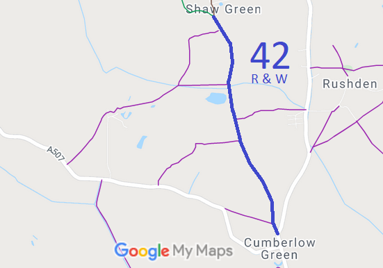
Annotated map reproduced courtesy of Googlemaps.
We need a volunteer to photograph this route for this year's Access and Riding Rights of Way Survey. It's easy - just take photographs (safely) when you use the path. Find out more!
| Paths Greenways Bridleways Tracks | ||
| PG: OBJECTS: PROMOTION: Rushden and Wallington 42 Shaw Green Lane | ||
Annotated map reproduced courtesy of Googlemaps. |
This route starts in Shaw Green at the junction of Rushden and Wallington 24 bridleway and Rushden and Wallington 37 byway and runs generally southwards to join the C5 public road.
We need a volunteer to photograph this route for this year's Access and Riding Rights of Way Survey. It's easy - just take photographs (safely) when you use the path. Find out more! |
| Legal History 1846: Rushden tithe map shows no tithe apportionment on route. 1 Nov 1953: This route was not shown on the original definitive map and statement. DM sheet DM4-21. 31 Dec 1977: This route was shown as a footpath on the special review draft map and statement. DM sheet SR-13. There were objections. 6 Mar 1996: The Hertfordshire County Council (Rushden and Wallington 42 (Shaw Green Lane)) Modification Order 1996 (confirmed 26 Jan 1998 after public inquiry, FPS/M1900/7/9) added this route to the definitive map and statement as a bridleway. |
Definitive Statement (4 Dec 2015)
Path: [Rushden and Wallington] 42. Status: Bridleway. Definitive Map sheets: 13 and 14 Commences at junction with county road at Cumberlow Green at TL 3008 3064 thence generally NNW for approx 50m to a junction with FP23 Clothall at TL 3006 3069, continuing in the same general direction for approx 600m to a junction with FP18 Clothall at TL 2981 3124, and for a further 380m approx to a junction with FP Clothall 17 at Shaw Green at TL 2965 3200, continuing for a final 90m approx to a junction with BOAT37 and BR24 at Shaw Green at TL 2962 3210. Width: Varies from 5 to 20m as shown cross hatched on the plan forming part of the Hertfordshire County Council (Rushden and Wallington 42 (Shaw Green Lane)) Modification Order 1996. The minimum width of the Order route across Shaw Green being 5 metres. |
© 2021 Patchetts Green Bridleways Trust.
File reference: EC012.
