Legal History
1 Nov 1953: Sandon 49 was not recorded on the original definitive map and statement. DM sheet DM4-22.
1 Nov 1953: Rushden 14 was recorded as a bridleway on the original definitive map and statement. DM sheet DM4-22.
31 Dec 1977: Sandon 49 and Rushden & Wallington 14 were shown as bridleways on the special review draft map and statement. DM sheet SR-14.
9 Mar 2024: Application to record the gap on the map between Rushden and Wallington 14 BW and the public road. HCC reference NH/355.
| Path |
Application |
Certificate |
Direction |
Inv Report |
Order |
Confirmed |
| EC786A |
9 Mar 2024 NH/355 |
28 May 2024 |
|
|
|
|
|
Definitive Statement (4 Dec 2015)
Path: [Sandon] 49. Status: Bridleway.
Definitive Map sheet: 14
Commences from county road at Beckfield Farm thence south-west to parish boundary to
join BR14 in Rushden parish.
Path: [Rushden and Wallington] 14. Status: Bridleway.
Definitive Map sheet: 14
Commences from end of county road at southern corner of Offley Green thence NE to
southern edge of Friars Wood thence E and NE along same to enter wood thence N along
Friars Lane and parish boundary to junction with FP19 W of Beckfield Farm.
Need to amend Rushden 14 statement to record junction with Sandon 49 BW.
|
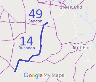

 As part of the British Horse Society's work to record paths before
Path Extinguishment Day,
it was spotted that Rushden and Wallington 14 on the definitive map did not reach the road to the south as recorded on the List of Streets. The historical evidence showed a continuous route, so an application was made in 2024 to record the gap.
