Patchetts Green Bridleways Trust
 PG: OBJECTS: PROMOTION: Sarratt 76, 77, 77A, 78 BW The Grove
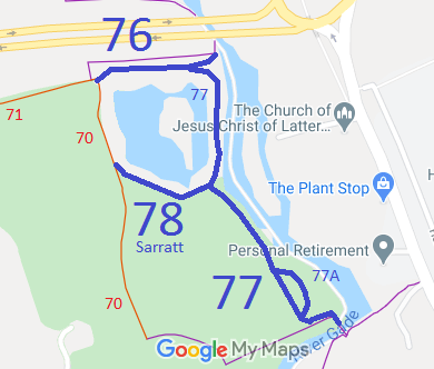
Map showing Sarratt bridleways at The Grove
Annotated map reproduced courtesy of Googlemaps.
Sarratt 76 runs from Sarratt 71 restricted byway roughly parallel to the footpath, to the towpath of the Grand Union Canal.

Sarratt 77 joins Sarratt 76 and runs as a bridleway generally southwards to the foot of the bridge over the Grand Union Canal.

Sarratt 77A is a bridleway loop off Sarratt 77.

Sarratt 78 is a bridleway joining Sarratt 77 northeastwards to Sarratt 70 restricted byway.

We need a volunteer to photograph these routes for this year's Access and Riding Rights of Way Survey. It's easy - just take photographs (safely) when you use the path. Find out more!

BHS PGBT These paths were negotiated as part of planning gain where there was substantial development at The Grove. The initial proposal was to add a cycle track, but this was able to be changed to bridleway within the land ownership boundary. Spurs were included to link to the tow path of the Grand Union Canal in two places, so that the routes could be extended if British Waterways (as it was then) could be persuaded to be helpful.

Legal History
25 Jun 2002: Sarratt 76, 77, 77A and 78 bridleways were created by The Grove Public Path Creation Agreement 2002.
15 Aug 2003: The Hertfordshire County Council (Sarratt Bridleways 76, 77, 77A and 78) Legal Event Modification Order 2003 was made, adding the bridleways created in 2002 to the definitive map and statement.
Definitive Statement (4 Dec 2015)
Path: [Sarratt] 76.  Status: Bridleway.  Definitive Map sheet: 83
Commences from the junction of Restricted Byway 70, Restricted Byway 71 and FP 74 Sarratt, east of Clarendon Park Farm at TQ 0831 9938 thence generally eastwards for approximately 170 metres to a junction with the canal towpath at TQ 0848 9941.
Width: 5m

Path: [Sarratt] 77.  Status: Bridleway.  Definitive Map sheet: 83
Commences from a point approximately 140 metres east from Clarendon Park Farm along BR 76 at TQ 0843 9940 thence generally southwards, west of the Grand Union Canal for a distance of 465 metres to join FP 50 Sarratt at TQ 0862 9907 and continuing eastwards to the canal towpath at TQ 0864 9906 terminating at the footbridge.
Width: 5m

Path: [Sarratt] 77A.  Status: Bridleway.  Definitive Map sheet: 83
Commences from a point approximately 350 metres south along BR 77 at TQ 0856 9911, loops for a distance of approximately 70 metres to the north-east side of BR 77 before rejoining it at TQ 0860 9907.
Width: 5m

Path: [Sarratt] 78.  Status: Bridleway.  Definitive Map sheet: 83
Commences from a point approximately 200 metres south along BR 77 at TQ 0847 9924 thence westwards to join Restricted Byway 70 Sarratt at TQ 0834 9928.
Width: 5m

Maintainability
These routes are maintainable at the public expense by virtue of s.36(2)(d) Highways Act 1980 as they were created by a Public Path Creation Agreement. [Dedicated by PPCA]

© 2025 Patchetts Green Bridleways Trust. File reference: ED058. HCC reference: 3R/46/CRE.

Stats2