image of Shenley 41 bridleway taken in 2025 showing path with hedge on the left and open fields to the right
 PG: OBJECTS: PROMOTION: Shenley 41 Bridleway
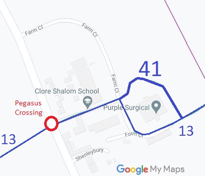
Map showing Shenley 41 bridleway
Annotated map reproduced courtesy of Googlemaps.
Strategic significance: This path forms part of two of the community circuits planned by the Trust and BHS for the area: the Aldenham Parish Ride and the Shenley Parish Ride.

As a result of development at Shenleybury in 2010, the route of Shenley 13 bridleway passes through a car park. The British Horse Society and the PGBT Trustees objected to this as it would result in a less commodeous path. As a result, the developers offered a new bridleway skirting their property. The legal work was completed on 26 Mar 04, and the path came into use once the physical construction and fencing had been completed. Unfortunately, the Borough Council agreed to 3m (10ft) of the path being a hard surface with 1m (3ft 3in) being grass. The Trust preferred more grass, as the line of Bridleway 13, which is already hard, was already suitable for walkers and cyclists. We were delighted when the developer just left the entire surface as grass!

Campaigning for new paths and safer road crossings costs money in postage and copying. Help us do more, so that more paths can be created!

Legal History
20 Jun 1953: The route was not recorded on the original definitive map and statement.
26 Mar 2004: The Shenleybury Public Path Creation Agreement 2004 created a bridleway to avoid part of the new car park at Shenleybury.
5 Mar 2010: The Hertfordshire County Council (Shenley 41) Legal Event Modification Order 2010 added the bridleway dedicated in the public path creation agreement to the definitive map and statement.
Definitive Statement (1 Dec 2009)
Path: [Shenley] 41.  Status: Bridleway
Commences at Farm Close at the junction with BR13 at TL 1833 0198 and runs generally NE for approximately 55 metres to TL 1836 0202 and then continues generally SE for approximately 90 metres to TL 1842 0196 where it joins BR13.
Width: 4 metres
Limitations: None
Maintainability
This route is maintainable at the public expense by virtue of s.36(2)(d) Highways Act 1980 as it was created by a Public Path Creation Agreement. [Dedicated by PPCA]

© 2025 Patchetts Green Bridleways Trust. File reference: ED077.

Stats2
