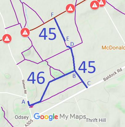
Herts Map Cambs Map
Annotated map reproduced courtesy of Googlemaps.
A volunteer has kindly photographed this route for this year's Access and Riding Rights of Way Survey. The web page will be updated in due course. Find out more!
| Patchetts Green Bridleways Trust | ||
| PG: OBJECTS: PROMOTION: Steeple Morden 45 and 46 BW | ||
Herts Map Cambs Map Annotated map reproduced courtesy of Googlemaps. |
A volunteer has kindly photographed this route for this year's Access and Riding Rights of Way Survey. The web page will be updated in due course. Find out more! |
|
| Legal History 29 Jul 1991: The County of Cambridgeshire (Public Bridleway No 46, Steeple Morden) Public Path Diversion Order 1997 (confirmed 6 Oct 1992) diverted Steeple Morden 46 to its present alignment (A-B), and upgraded part (B-C) of Steeple Morden 45 from footpath to bridleway. 1992: Cambridgeshire County Council entered into public path creation agreements upgrading Steeple Morden 45 footpath from B to D and E to F to bridleway. |
Definitive Statement - Cambridgeshire (11 May 2016)
Path: [Steeple Morden] 45. Status: Bridleway. Starts at Ashwell Street as a bridleway and proceeds along a track for approximately 980 metres to White Cottage and Mordern Grange Farm; continues along farm road as a footpath through farmyard. Then continues as a bridleway along hardened roadway 10 ft wide at edge of arable field and alongside plantation under railway bridge to its exit at field gate and into the Royston-Baldock Road (A505). Width: 3m Path: [Steeple Morden] 46. Status: Bridleway.
|
© 2021 Patchetts Green Bridleways Trust.