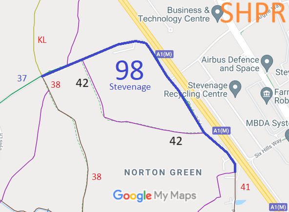
Annotated map reproduced courtesy of Googlemaps.
We need a volunteer to photograph this route for this year's Access and Riding Rights of Way Survey. It's easy - just take photographs (safely) when you use the path. Find out more!
| Paths Greenways Bridleways Tracks | ||
| PG: OBJECTS: PROMOTION: Stevenage 98 BW | ||
| Stevenage Horse and Pony Route: Anti-clockwise: Stevenage 41. Middle: Stevenage 42. Clockwise: Stevenage Kitching Lane. | SHPR | |
Annotated map reproduced courtesy of Googlemaps. |
This route starts from Stevenage 41 byway and continues northwestwards to a junction with Stevenage 42 (a part of the Stevenage Horse and Pony Route). It continues northwestwards before turning westwards along Dyes Lane to another junction with Stevenage 42, and continues generally westwards to Kitching Lane (unsurfaced public road).
We need a volunteer to photograph this route for this year's Access and Riding Rights of Way Survey. It's easy - just take photographs (safely) when you use the path. Find out more! |
| Legal History 1983: The parts of the route either side of Stevenage 42 are shown in Stevenage Borough Council leaflet as part of Phase 1 SHPR which is stated as being open for use. 8 Dec 2004: The parts of the route either side of Stevenage 42 are described as part of the existing Stevenage Horse and Pony Route on the Stevenage Local Plan map. |
Definitive Statement (4 Dec 2015)
Path: [Stevenage] 98. Status: Bridleway. Definitive Map sheet: 29 Commences from junction with Kitching Lane, thence east and south along Yes Lane to Chadwell Road. The statement reference to 'Yes Lane' should read 'Dyes Lane'. |
© 2023 Patchetts Green Bridleways Trust.
