Legal History
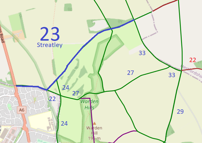
19 Jan 1996: The route is shown as Streatley 23 bridleway on the Definitive Map and Statement for the Former Borough of Dunstable, the Borough of Luton and the Former Leighton Buzzard and Linslade Urban and Luton Rural Districts. Map sheet 20.
28 Jan 2019: Application for restricted byway status. CBC reference 56.
26 Mar 2023: Application that the Secretary of State direct Central Bedfordshire Council to determine the application within a set period of time.
16 Oct 2023: Secretary of State directed Central Bedfordshire Council to determine the application by 16 Apr 24. PINS reference ROW/3319362.
7 Nov 2023: Central Bedfordshire Council advises Secretary of State that decision to make order for RB has been taken.
23 Jan 2026: The Central Bedfordshire Council (Definitive Map and Statement for Central Bedfordshire) (Streatley Restricted Byway No 23) Modification Order 2026, made 23 Jan 2026 and confirmed 8 May 2026, upgraded the county boundary bridleway to restricted byway.
|
| Application Process |
| Path |
Application |
Certificate |
Direction |
Inv Report |
Order |
Confirmed |
| EB900 |
28 Jan 2019 CBC 56 |
28 Apr 2019 |
16 Oct 2023 (6mo) |
N/A |
23 Jan 2026 |
8 May 2026 |
|
Definitive Statement (20 Jan 2026)
Path: [Streatley] 23. Status: Restricted Byway.
From: A6, barton Road
To: BOAT No 8, Hexton and BOAT No 23, Lilley
This path is a restricted byway.
It starts at its junction with the A6, Barton Road at Ordnance Survey Grid Reference (OS GR) TL 0802 2654 in a generally easterly direction for approximately 418 metres along the top of Drays Ditches to its junction witht Bridleway No 22, Streatley at OS GR 0844 2649 then continues in a generally north-easterly direction for approximately 195 metres to its junction with Bridleway No 24, Streatley at OS GR TL0857 2663 then continues in a generally north-easterly direction for approximately 1022 metres to its junction with Bridleway No 31, Streatley and Bridleway No 32, Streatley at OS GR TL 0929 2733 then continuesnin a generally east-north-easterly direction for approximately 340 metres to its junction with Bridleway No 33, Streatley and Bridleway No 41, Streatley at OS GR TL0960 2746 then continues in a generally east-north-easterly direction for approximately 285 metres to terminate at its junction with the Hertfordshire County Council boundary, BOAT No 8 Hexton and BOAT No 23, Lilley at OS GR TL 0985 2759.
The width of Restricted Byway No 23, Streatley varies between 6 metres and 10 metres wide. The width is 5 metres wide between OS GR TL 0802 2654 and OS GR TL 0844 2649 as defined by the width of the top of Drays Ditches.
|
Maintainability
This route is maintainable at the public expense because it was a highway before 1835.
|
|