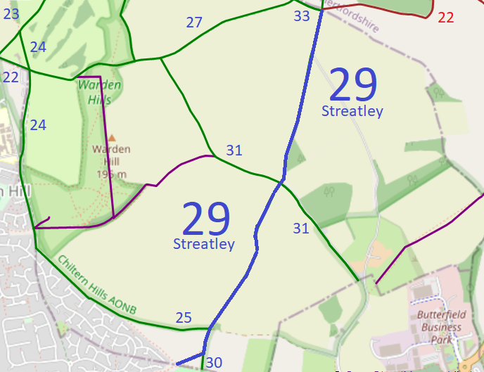
Map data from © OpenStreetMap and Central Bedfordshire Council.
We need a volunteer to photograph this route for the Access and Riding Rights of Way Survey. It's easy - just take photographs (safely) when you use the path. Find out more!
| Paths Greenways Bridleways Tracks | ||
| PG: OBJECTS: PROMOTION: Streatley (Bedfordshire) 29 | ||
| Luton Orbital Bridleroute: Anti-clockwise: Streatley 25. Clockwise: Lilley 22. | LOB | |
Map data from © OpenStreetMap and Central Bedfordshire Council. |
This route starts from the Luton Borough Boundary and continues northeastwards to a junction with Streatley 30 bridleway. It then continues northeastwards through a junction with Streatley 25 bridleway (Luton Orbital Bridleroute) then to a crossroads with Streatley 31 bridleway before ending at a junction with Streatley 33 bridleway, Lilley 16 bridleway and Lilley 22 byway (Luton Orbital Bridleroute) at the county boundary.
We need a volunteer to photograph this route for the Access and Riding Rights of Way Survey. It's easy - just take photographs (safely) when you use the path. Find out more! |
|||
| Legal History 19 Jan 1996: The route is shown as Streatley 29 bridleway on the Definitive Map and Statement for the Former Borough of Dunstable, the Borough of Luton and the Former Leighton Buzzard and Linslade Urban and Luton Rural Districts. Map sheets 20 and 21. |
© 2023 Patchetts Green Bridleways Trust.
