Legal History
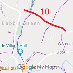
2 Feb 1953: Recorded as Ware Rural 10 FP on original definitive map and statement.
DM2-24 (Herts 30 NW)
29 Oct 2020: Application made to record route as RB. HCC reference EH/498.

|
| Application Process |
| Path |
Application |
Certificate |
Direction |
Inv Report |
Order |
Confirmed |
| EC756 |
29 Oct 2020 EH/498 |
7 Dec 2020 |
|
|
|
|
|
Definitive Statement (4 Dec 2015)
Path: [Wareside] 10. Status: FP.
Definitive Map sheet: 46
Commences from county road Helham Green by Almshouses thence NW along Hogtrough
Lane across FP8 and footbridge over Nimney Bourne to county road at Babb's Green.
|
Maintenance
This route is maintainable at the public expense because it was a highway before 1835.
This route is maintainable at the public expense because it was a footpath or bridleway existing before 30 Apr 1959.
|
|