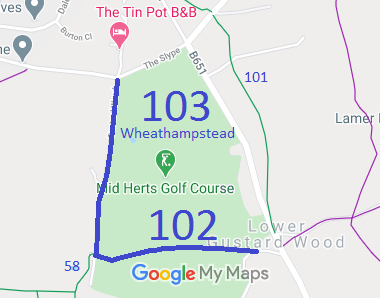
Annotated map reproduced courtesy of Googlemaps.
We need a volunteer to photograph this route for this year's Access and Riding Rights of Way Survey. It's easy - just take photographs (safely) when you use the path. Find out more!
| Paths Greenways Bridleways Tracks | ||
| PG: OBJECTS: PROMOTION: Wheathampstead 103 BW | ||
Annotated map reproduced courtesy of Googlemaps. |
This is the north-south route at the western side of the Mid Herts Golf Course. It starts at the junction of
Wheathampstead 58 and Wheathampstead 102 bridleways and runs northwards to The Slype (public road).
We need a volunteer to photograph this route for this year's Access and Riding Rights of Way Survey. It's easy - just take photographs (safely) when you use the path. Find out more! |
| Legal History 1938: The route is not shown on the Hertfordshire County Council ROW survey. Map St Albans Rural 4. 20 Jun 1953: The route was not recorded on the original definitive map and statement. DM sheet DM3-07. 31 Dec 1977: The route was not shown on the special review draft map and statement. DM sheet SR-56. Apr 2002: Application to record a bridleway (user evidence). HCC reference STA/81. 1 Dec 2006: The Mid-Herts Golf Club Dedication Agreement 2006 (made under s.25 Highways Act 1980) dedicated this bridleway. 2007: Hertfordshire County Council (Wheathampstead 102 and Wheathampstead 103) Legal Event Modification Order 2007 added the bridleway to the definitive map. |
Definitive Statement (4 Dec 2015)
Path: [Wheathampstead] 103. Status: Bridleway. Definitive Map sheet: 42 Commences from a junction with Wheathampstead 102 at TL 1712 1568 and continuing in a generally northerly direction for approximately 525 metres to The Slype at TL 1717 1619. Width: Between 3.7 metres and 6.2 metres between TL 1712 1572 and TL 1717 1619 with a pinch-point of 2.9 metres at TL 1716 1613 as shown crosshatched on the Hertfordshire County Council (Wheathampstead 102 and Wheathampstead 103) Legal Event Modification Order 2007 Order Plan 2 4 metres between TL 1712 1568 and TL 1712 1572 Limitations: None |
© 2022 Patchetts Green Bridleways Trust. File reference: EC188.