| Paths Greenways Bridleways Tracks | ||
| PG: OBJECTS: PROMOTION: Wheathampstead 105 RB | ||
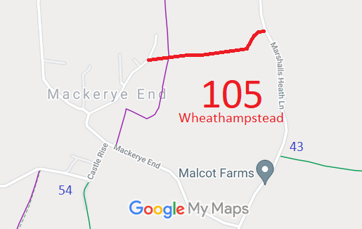
![]() Annotated map reproduced courtesy of Googlemaps. |
This route starts from Mackerye End (public road) and continues generally eastwards to Marshalls Heath Lane (public road).
We need a volunteer to photograph this route for this year's Access and Riding Rights of Way Survey. It's easy - just take photographs (safely) when you use the path. Find out more! |
|||
As part of the British Horse Society's work to record paths before
Path Extinguishment Day,
it was spotted that this route appeared to be the continuation of the public road, Mackerye End. The historical evidence showed a continuous route, so an application was made in 2014 to record the route.
The County Council agreed with the application and an order was made in 2016 and confirmed unopposed.
This is a good example of 'perfectly obvious paths' that would be extinguished by the Countryside and Rights of Way Act 2000 if an application had not been made in time. | ||||
| Legal History 15 Dec 2014: Application for part byway part restricted byway. HCC reference STA/146. 22 Apr 2016: The Hertfordshire County Council (Wheathampstead 29 and 105) Modification Order 2016 (confirmed 16 Sep 2016) added this route to the definitive map and statement |
Definitive Statement (4 Dec 2015)
Path: [Wheathampstead] 105. Status: Bridleway. Definitive Map sheet: 42 Commences from Mackerye End (public road) E of Holly Bush Cottage at TL 1588 1591 and runs generally E for approx. 420m to Marshalls Heath Lane (public road) at TL 1627 1601. Width: Varies between 3m-10m between TL 1588 1591 and TL 1627 1601 as shown in the HCC (Wheathampstead 29 and 105) Modification Order 2016. Limitations: None |
© 2023 Patchetts Green Bridleways Trust. File reference: EC822. HCC reference: STA/146.