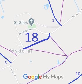
Annotated map reproduced courtesy of Googlemaps.
We need a volunteer to photograph this route for the Access and Riding Rights of Way Survey. It's easy - just take photographs (safely) when you use the path. Find out more!
| Paths Greenways Bridleways Tracks | ||
| PG: OBJECTS: PROMOTION: Wyddial 18 BW | ||
Annotated map reproduced courtesy of Googlemaps. |
This route runs from one point on Wyddial Lane/Vicarage Road to another point on the same road.
We need a volunteer to photograph this route for the Access and Riding Rights of Way Survey. It's easy - just take photographs (safely) when you use the path. Find out more! |
| Legal History Wyddial 18 was recorded as a bridleway on the original (1953) definitive map. The Hertfordshire County Council (Wyddial 16 and 18) Public Path Extinguishment Order 2009 removed Wyddial 18 FP and 10m of Wyddial 16 FP, and The Hertfordshire County Council (Wyddial Bridleway) Public Path Creation Order 2009 replaced them with Wyddial 18 BW on a slightly different alignment (avoiding the garden). |
Definitive Statement (4 Dec 2015)
Path: [Wyddial] 18. Status: Bridleway. Definitive Map sheet: 15 Commences at a junction with Wyddial Road at TL 3735 3154 running generally NE for approximately 295 metres to a junction with Wyddial Footpath 16 at TL 3760 3168 then continuing in a generally north easterly direction for approximately 15 metres to re-join the Wyddial Road at TL 3761 3170. Width: 4m. Limitations: None. |
© 2024 Patchetts Green Bridleways Trust.
File reference: ED143.
