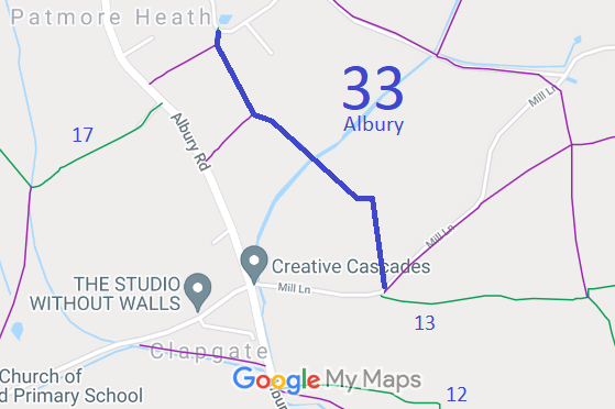
Annotated map reproduced courtesy of Googlemaps.
We need a volunteer to photograph this route for this year's Access and Riding Rights of Way Survey. It's easy - just take photographs (safely) when you use the path. Find out more!
| Paths Greenways Bridleways Tracks | ||
| PG: OBJECTS: PROMOTION: Albury 33 | ||
Annotated map reproduced courtesy of Googlemaps. |
This route starts from the public road at Patmore Heath, and continues south to a junction with Itch Lane then generally southeastwards to end on Mill Lane near Albury 13 bridleway.
We need a volunteer to photograph this route for this year's Access and Riding Rights of Way Survey. It's easy - just take photographs (safely) when you use the path. Find out more! |
| Legal History 2 Feb 1953: The section from Albury 32 to Albury 33A was recorded as a footpath on the original definitive map and statement. The rest of the current route was not recorded. DM sheet DM1-13 (Herts 14 SW). 31 Dec 1977: The section from Albury 32 to Albury 33A was shown as a footpath on the special review draft map and statement. The rest of the current route was not shown. DM sheet SR-25 (TL 42 NW). 19 Dec 2003: The Hertfordshire County Council (Albury 33) Modification Order 2003 (confirmed 12 Jul 2012) upgraded the footpath and added the bridleway to the definitive map and statement. |
Definitive Statement (4 Dec 2015)
Path: [Albury] 33. Status: Bridleway. Definitive Map sheet: 25 Commences from County Road at Patmore Heath by Hitch Lane Cottage, at TL 4421 2552, thence SW to the junction with FP 32, thence SE along path to junction with Footpath 33a at TL 4429 2535, thence SE to wood at TL 4453 2517, thence generally S to Mount Pleasant, Mill Lane at TL 4458 2498. Width: 4m (points A-B-C) TL 4421 2552 to TL 4429 2535 and 2.4m (points C-D-E) TL 4429 2535 to TL 4458 2498 |
© 2022 Patchetts Green Bridleways Trust.
File reference: EC210.
