Patchetts Green Bridleways Trust
 PG: OBJECTS: PROMOTION: Aldenham 26 BW
Map showing Aldenham 26 bridleway
Annotated map reproduced courtesy of Googlemaps.
This bridleway runs from Oakridge Avenue to Watling Street, almost opposite Aldenham 68. The easternmost part is concurrent with Kitswell Way (a road). Take care when crossing Watling Street.

At the time of the 2021 Access Survey (10 Oct 21), no gates were across the path and it was signposted at each end.

Photograph of Aldenham 26
Path leaves Kitswell Lane
Photo: Michael Rackham, 7 Oct 2021
Photograph of Aldenham 26
Sign at Kitswell Way
Photo: Michael Rackham, 7 Oct 2021
Photograph of Aldenham 26
Heading westwards
Photo: Michael Rackham, 7 Oct 2021
Photograph of Aldenham 26
Continuing northwestwards
Photo: Michael Rackham, 7 Oct 2021
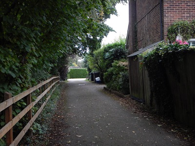
Photograph of Aldenham 26
Approaching Oakridge Avenue
Photo: Michael Rackham, 7 Oct 2021
Photograph of Aldenham 26
View from Oakridge Avenue
Photo: Michael Rackham, 7 Oct 2021

Legal History
20 Jun 1953: The route was recorded as a bridleway on the original definitive map and statement. DM sheet DM3-31 (TL10SE).
The Stopping Up of Highways (County of Hertford) (No. 9) Order 1963 diverted the bridleway.
31 Dec 1977: The route was shown as a bridleway (in its new alignment) on the special review draft map and statement. DM sheet SR-77 (TL10SE).
The Hertsmere Borough Council (Footpath 26 and Bridleway 26) (Prohibition of Cycling) Order 1979 prohibits cyclists from using this bridleway.
Definitive Statement (4 Dec 2015)
Path: [Aldenham] 26.  Status: FP/BW.  Definitive Map sheet: 77
Commences as FP from Oakridge Lane thence SE alongside brook to Brook Drive thence to Oakridge Avenue thence as BR to join Watling Street opposite The Avenue.
Maintainability
This route is maintainable at the public expense because it was a footpath or bridleway existing before 30 Apr 1959.

© 2025 Patchetts Green Bridleways Trust.

Stats2