Legal History
1842: Caldecote and Newnham 9 was shown on the Newnham tithe map as not subject to an apportionment.
1843: Parts of route stopped up as cart road by Quarter Sessions reserving a bridleway of 8ft width.
1 Nov 1953: Not recorded on the original definitive map and statement.
4 Feb 2004: EHFS application for bridleway. HCC reference NH/163.
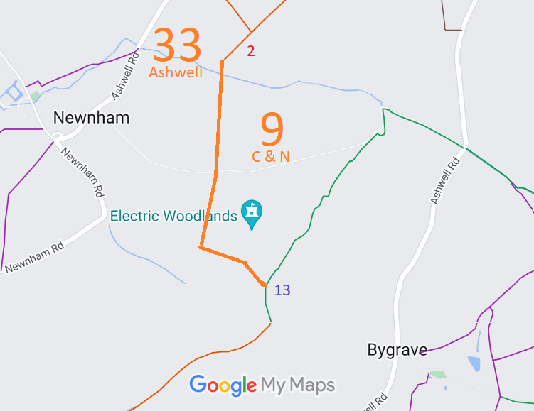
27 Jul 2018: The Hertfordshire County Council (Ashwell 33 and Caldecote & Newnham 9) Modification Order 2018 (confirmed 18 May 2023) added this route to the definitive map as a bridleway.
10 Oct 2022: The Planning Inspectorate propose to determine the order by the written representation method. PINS reference ROW/3296810.
19 Jun 2023: Confirmed order advertised by the County Council.
| Application Process |
| Path |
Application |
Certificate |
Direction |
Inv Report |
Order |
Confirmed |
| EC416 |
4 Feb 2004 NH/163 |
Not known |
N/A |
5 Oct 2017 |
27 Jul 2018 |
18 May 2023 |
| Written Representations Timetable |
| Path |
Start Date |
OMA SOC |
Other SOCs |
Comments on SOCs |
Further Comments |
Result |
| EC416 |
24 Nov 2022 |
8 Dec 2022 |
19 Jan 2023 |
2 Mar 2023 |
N/A |
18 May 2023 |
|
Definitive Statement (20 Jul 2018)
Path: [Ashwell] 33. Status: Bridleway.
Definitive Map sheet: 6
Commences from RB2 at TL 2536 3785 then runs S along field edge on the E side of field boundary for approx 25m to join Caldecote & Newnham BR9 and the parish boundary at TL 2536 3783.
Width: 8 feet (2.4m)
Limitations: None
Path: [Caldecote & Newnham] 9. Status: Bridleway.
Definitive Map sheet: 6
Commences from Ashwell BR33 and parish boundary at TL 2536 3783 then runs S through copse for approx. 60m to cross Cat Ditch at TL 2534 3777. Continues S on W boundary of copse for approx. 320m to TL 2532 3745. Continues S through copse for approx. 125m to TL 2533 3733 and continues S on E bundary of copse for approx. 100m to cross farm track at TL 2532 3722. Continues SSW through copse for approx. 75m to NW field edge at TL 2529 3716. Continues SSW for approx 210m across field to TL 2521 3696 then SE for approx. 380m across field to TL 2553 3677, W of Bygrave Plantation. Continues SSE for approx. 180m across field to parish boundary and junction with Bygrave BR13 at TL 2562 3661, S of Bygrave Plantation.
Width: 8 feet
Limitations: None
|
 The East Herts Footpaths Society performed the research and made the application for this route to be recorded as a bridleway. The county council agreed and made an order to do so in 2018. There were objections, and so the order had to be submitted to the secretary of state for determination. On 18 May 2023, the Inspector confirmed the order, and so recorded the bridleway rights.
The Trust and the BHS thank the EHFS for performing the initial research and applying for the path to be recorded.
