Legal History
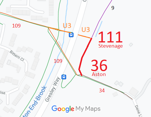
1840: Aston 36 was shown on the Aston tithe map as not subject to an apportionment.
2 Feb 1953: Aston 36 and Stevenage 111 were not recorded on the original definitive statement. DM sheet DM2-08 (Herts 21 NW). At the time it was part of Dene Lane, a public road.
31 Dec 1977: Aston 36 and Stevenage 111 were not shown on the special review draft map and statement.
DM sheet SR-30 (TL22SE).
23 Sep 2011: The Hertfordshire County Council (Aston 34 & 35, Stevenage 109)
Modification Order 2011, confirmed amended 22 Oct 2013, added this restricted byway.
|
Definitive Statement (4 Dec 2015)
Path: [Stevenage] 111. Status: Restricted Byway.
Definitive Map sheet: 30
Commences at the junction with Aston RB 36 at TL 2694 2289 continuing generally north-
easterly for approximately 10 metres to TL 2694 2290 where it joins Aston FP 9.
Width: 3 metres
Limitations: None
Path: [Aston] 36. Status: Restricted Byway.
Definitive Map sheet: 30
Dene Lane. Commences at the junction of Aston BOAT 34 and Stevenage RB 109 at TL
2691 2282 continuing generally north-easterly for approximately 55 metres to TL 2694 2289
where it joins Stevenage RB 111.
Width: 3 metres
Limitations: None
|