Paths Greenways Bridleways Tracks
 PG: OBJECTS: PROMOTION: Bengeo Rural 11 FP
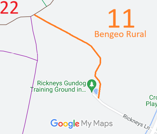
Map showing recorded Bengeo Rural paths
Annotated map reproduced courtesy of Googlemaps.
This route runs from Rickneys Lane (public road) to Bengeo Rural 22 byway.

We need a volunteer to photograph this route for the Access and Riding Rights of Way Survey. It's easy - just take photographs (safely) when you walk the path. Find out more!

Legal History
1822: Bengeo Rural is shown in the manner of 'Lanes and Bridleways' on Bryant's map.
1843: Bengeo Rural 11 is shown on the Bengeo tithe map coloured ochre and with no apportionment.
1851: This route is not in an area affected by the Inclosure of parts of the parish.
2 Feb 1953: Bengeo Rural 11 was recorded as a footpath on the original definitive map and statement. DM sheet DM2-21 (Herts 29 NE).
31 Dec 1977: The route was shown as a footpath on the special review draft map and statement. DM sheet SR-45 (TL31NW).
Definitive Statement (4 Dec 2015)
Path: [Bengeo Rural] 11.  Recorded Status: Footpath.  Definitive Map sheet: 45
Commences at end of county road E of Rickneys thence generally NW along Occupation Road to footpath and junction with BOAT 22 E of Flowersash Wood.
Maintainability
This route is maintainable at the public expense because it was a footpath or bridleway existing before 30 Apr 1959.

© 2024 Patchetts Green Bridleways Trust. File reference: EC1229.

Stats2