Paths Greenways Bridleways Tracks
 PG: OBJECTS: PROMOTION: Berkhamsted Used Route between UCR 1 and UCR 2
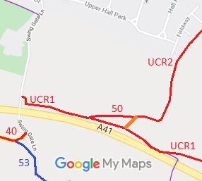
Map showing used route in Berkhamsted
Annotated map reproduced courtesy of Googlemaps.
This short route, shown in orange, starts at the junction of Berkhamsted 50 Byway and Berkhamsted UCR2 and leads south-westwards to Berkhamsted UCR1.

This route is in use by riders but has not yet been recorded, so the BHS is collecting evidence to enable this to happen.

BHS If you have ridden the route, please download a user evidence form and then follow the instructions and return the form to us. It only takes a few minutes to fill in (the whole form fits on one side of a piece of A4 paper). If you have any other questions, please email us.

Legal History
20 Jun 1953: Not recorded on the original definitive map.
10 Apr 2020: Application for bridleway. HCC reference DAC/167.
8 Feb 2025: This path is affected by planning application 24/02868/MOA.
Definitive Map sheet: 65

© 2024 Patchetts Green Bridleways Trust. File reference: EC616A.