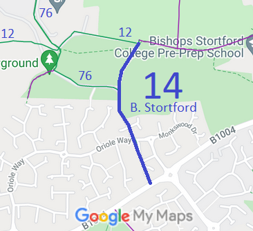
Annotated map reproduced courtesy of Googlemaps.
We need a volunteer to photograph this route for this year’s Access and Riding Rights of Way Survey. It's easy - just take photographs (safely) when you use the path. Find out more!
| Paths Greenways Bridleways Tracks | ||
| PG: OBJECTS: PROMOTION: Bishop's Stortford 14 BW | ||
Annotated map reproduced courtesy of Googlemaps. |
This bridleway starts on the Much Hadham Road and runs generally northwards, through a junction with Bishop's Stortford 76 bridleway, and onwards to end on
Bishop's Stortford 12 bridleway.
We need a volunteer to photograph this route for this year’s Access and Riding Rights of Way Survey. It's easy - just take photographs (safely) when you use the path. Find out more! |
| Legal History The numbering of paths in Bishop's Stortford before 2000 was unlike that in the rest of Hertfordshire! 2 Feb 1953: The route was recorded as CRF (Carriage Road used as a Footpath) M2 on the original definitive statement. DM sheet DM1-22. 31 Dec 1977: The route was shown as bridleway M2 on the special review draft map and statement. DM sheet SR-34. |
Definitive Statement (4 Dec 2015)
Path: [Bishop's Stortford] 14. Status: Bridleway/Footpath. Definitive Map sheet: 34 Much Hadham Road to FP12. Path leaves Much Hadham Road as BR just west of entrance to road to Stortford Park, crosses arable field and joins private road, continuing north and when private road turns west the path continues on the east of the arable field until it joins FP and BR12 in the north east corner. The statement refers to BW/FP but the map shows route as a bridleway. Error seems to come from former path M2 being part BW (now BW 14) and part FP (now FP 13). |
© 2022 Patchetts Green Bridleways Trust.
