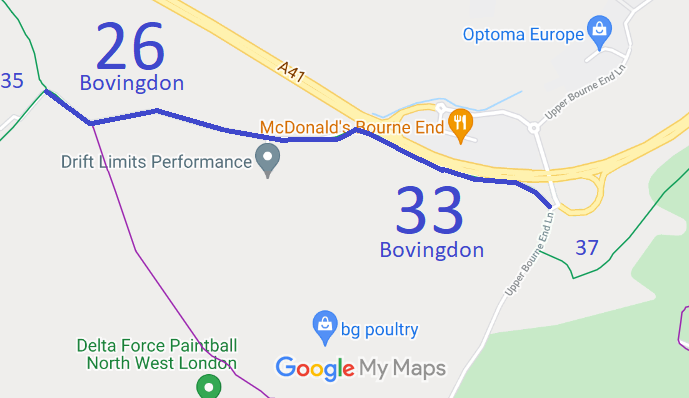
Annotated map reproduced courtesy of Googlemaps.
We need a volunteer to photograph this route for this year's Access and Riding Rights of Way Survey. It's easy - just take photographs (safely) when you use the path. Find out more!
| Paths Greenways Bridleways Tracks | ||
| PG: OBJECTS: PROMOTION: Bovingdon 26 and 33 | ||
Annotated map reproduced courtesy of Googlemaps. |
This route starts as Bovingdon 26 bridleway at a junction with Bovingdon 35 bridleway. It continues generally eastwards, becoming Bovingdon 33 at the side of the A41 trunk road, continuing to Upper Bourne End Lane (public road) not far from Bovingdon 37 bridleway.
We need a volunteer to photograph this route for this year's Access and Riding Rights of Way Survey. It's easy - just take photographs (safely) when you use the path. Find out more! |
| Legal History 20 Jun 1953: The Hertfordshire route was recorded as part CRF (Carriage Road used as a Footpath) and part footpath on the definitive map and statement. Part of the (2023) route fell in Ashley Green, Buckinghamshire, and so was not recorded in Hertfordshire. DM sheet DM3-20 (TL00NW). 31 Dec 1977: The Hertfordshire route was shown as a bridleway on the special review draft map and statement. Part of the (2023) route fell in Ashley Green, Buckinghamshire, and so was not recorded in Hertfordshire. DM sheet SR-65 (TL00NW). 2001: The Hertfordshire County Council (Bovingdon 26) Modification Order 2001 added this route to the definitive map and statement following a request by the Bovingdon Parish Council. 17 Apr 2009: The Hertfordshire County Council (Part of Bovingdon 26) Extinguishment Order 2009 (confirmed 19 Nov 2010) removed the route crossing the A41 trunk road. 17 Apr 2009: The Hertfordshire County Council (Bovingdon 26 to Bourne End Lane) Creation Order 2009 (confirmed 19 Nov 2010) created bridleway rights over Bovingdon 33 FP. 11 Mar 2011: The Hertfordshire County Council (Bovingdon 26 and 33) legal Event Modification Order 2011 recorded the effect of the 2009 extiinguishment and creation orders. 6 Oct 2022: Query about Bovingdon 26 definitive statement sent to HCC. Resolved 7 Oct 22. |
Definitive Statement (4 Dec 2015)
Path: [Bovingdon] 26. Status: Bridleway. Definitive Map sheet: 65 Commences at a junction with Bovingdon BR35 at Lower Farm and runs in a south-easterly direction for a distance of approximately 140 metres and then in an east-north-easterly direction then runs eastwards along a metalled track for approximately 500 metres, Width: Minimum 3.5 metres between junction with Bovingdon BR35 and TL 0088 0581. Between 2 and 4 metres as shown hatched on the plan contained in the Hertfordshire County Council (Bovingdon 26) Modification Order 2001. Limitations: None. The words in Path: [Bovingdon] 33. Status: Bridleway.
Definitive Map sheet: 65
|
© 2023 Patchetts Green Bridleways Trust.
File reference: EC199.
HCC reference: DAC/36/MOD; DAC/102/CRE/EXT.
