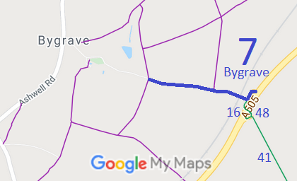
Annotated map reproduced courtesy of Googlemaps.
We need a volunteer to photograph this route for this year's Access and Riding Rights of Way Survey. It's easy - just take photographs (safely) when you use the path. Find out more!
| Paths Greenways Bridleways Tracks | ||
| PG: OBJECTS: PROMOTION: Bygrave 7 and 16 | ||
Annotated map reproduced courtesy of Googlemaps. |
This page is still being prepared.
We need a volunteer to photograph this route for this year's Access and Riding Rights of Way Survey. It's easy - just take photographs (safely) when you use the path. Find out more! |
| Legal History 1 Nov 1953: Bygrave 7 was recorded as a bridleway on the original definitive map and statement. DM sheet DM4-19 (Herts 8 NW). 31 Dec 1977: Bygrave 7 was shown as a bridleway on the special review draft map and statement. DM sheets SR-6. 12 Mar 2010: The Hertfordshire County Council (A505 Baldock Bypass) Legal Event Modification Order 2010 modified the definitive map and statement to show the changes made for the A505 bypass construction, namely the diversion of Bygrave 7 and creation of Bygrave 16. 2 Sep 2021: Missing finger post at junction with A505 reported to Hertfordshire County Council. |
Definitive Statement (4 Dec 2015)
Path: [Bygrave] 7. Status: Bridleway. Definitive Map sheets: 6 Commences from county road at SE corner of Park Wood thence E past FP8 thence across railway and continues to TL 2759 3592 and the junction with BR16 thence NE to TL 2763 3597 and E to join A505 (Baldock Bypass) and parish boundary at TL 2766 3597. Coexistent with a private vehicular right of access to Manor Farm. Width: 3 metres between TL 2756 3593 and TL 2766 3597 Limitations: None between TL 2756 3593 and TL 2766 3597 Path: [Bygrave] 16. Status: Bridleway.
Definitive Map sheets: 6 |
© 2022 Patchetts Green Bridleways Trust.
