Paths Greenways Bridleways Tracks
 PG: OBJECTS: PROMOTION: Clothall 27 and 28 BW - mainly the former Wallington Road
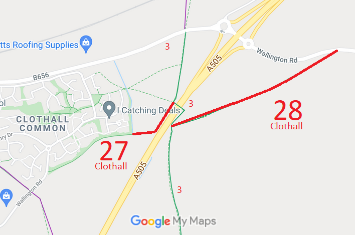
Map showing Clothall paths
Annotated map reproduced courtesy of Googlemaps.

Clothall 27 bridleway starts at a step over horse stile and junction with Wallington Road and runs generally eastwards along the old road alignment to the side of the A505. It turns north-eastwards to end at a junction with Clothall 3 bridleway, which goes across the A505 on a bridge.

Clothall 28 bridleway starts from Clothall 3 bridleway on the western side of teh A505. It then follows the former alignment of Wallington Road until it meets the modern alignment of Wallington Road (public road).

A volunteer has photographed this route for the 2022 Access and Riding Rights of Way Survey, and the page will be updated shortly. Find out more!

Clothall 27: At the time of the BHS 2022 Access Survey (19 Sep 22), there was a gate at the western end of the route with a 'step over' point for horses. The step is quite high. There were no signposts to indicate the existence of the route.

Clothall 28: At the time of the BHS 2022 Access Survey (19 Sep 22), there was a gate at the eastern end of the route with a 'step over' point for horses. In front of the step is a bollard set in a large concrete-filled tyre. This obstructs the path for equestrians. There were signposts to indicate the existence of the route at each end of the path.

Legal History
1 Nov 1953: Clothall 27 and 28 were not recorded on the original definitive statement. DM sheet DM4-22.
31 Dec 1977: Clothall 27 and 28 were not shown on the special review draft map and statement. DM sheet SR-22.
12 Mar 2010: The Hertfordshire County Council (A505 Baldock Bypass) Legal Event Modification Order 2010 added Clothall 27 and 28 BW to the definitive map and statement.
Definitive Statement (4 Dec 2015)
Path: [Clothall] 27.  Status: Bridleway.  Definitive Map sheets: 13
Commences from the former Wallington Road at TL 2584 3403 and continues E for 100m to outer W edge of A505 (Baldock Bypass) at TL 2594 3404, then NE following the outer W edge of A505 (Baldock Bypass) for approximately 170 metres to a junction with BR3 at TL 2603 3419.
Width: 3 metres
Limitations: None

Path: [Clothall] 28.  Status: Bridleway.  Definitive Map sheets: 13
Commences from a junction with BR3 at TL 2602 3407 and continues NE for approximately 870 metres along the former Wallington Road to meet Wallington Road at TL 2679 3445. Coexistent with a right of vehicular access by Hertfordshire County Council for maintenance purposes and crossed by a private vehicular right of access to premises approximately 130 metres from the junction with Wallington Road at TL 2679 3445.
Width: The same width as the existing length of the former Wallington Road over which it will run
Limitations: The right of Hertfordshire County Council to erect bollards and/or width restriction at TL 2679 3445

© 2024 Patchetts Green Bridleways Trust.