So far, additional bridleways have gone in on the north side, leading to Harper Lane at suitable crossing points, and paths have been added in New Shenley (Porters Park) to lead to Harperbury Hospital site.
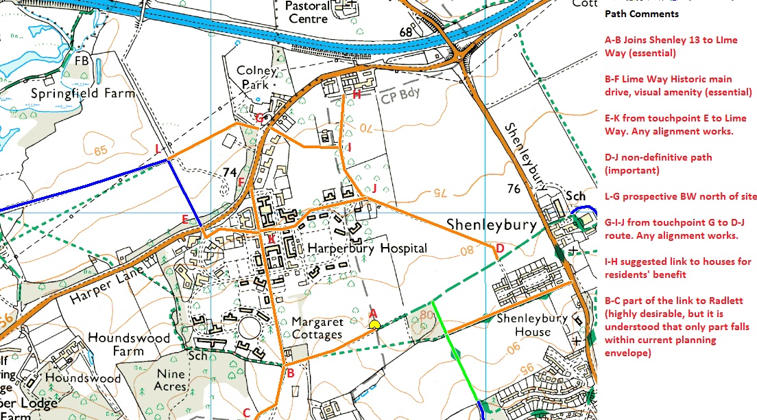
Now, the Hospital site is being redeveloped and we have this main chance to ensure that the link paths are put in at bridleway rather than footpath, cycleway or permissive status. Please email the developer to ask that the orange routes are all put in the planning application as bridleways.
The planning application has been made to St Albans City and Distrct Council. It can be seen here using reference 5/2015/0990.
Developer's webite: http://www.bloorharperburyhospital.co.uk/our-proposals.aspx
If you value the work we do, why not register your support? With more supporters, we would have more influence with local authorities.
Progress
- The Officer's report to the St Albans Planning Committee said,
- The s.106 agreement dated 27 May 2017 makes provision for public open space provision.
- The s.278 agreement dated 23 Feb 2018 provides for:
Installation of a Pegasus Crossing on Harper Lane as part of Phase 1 of the development. (This is at point E on the plan above.)
- 2019: The Pegasus Crossing at point E has been built.
4.11 "At the time of writing the report, the applicants have indicated their agreement to the creation of new Public Rights of Way (PRoW) to the south east and south west of the site which would link to existing routes leading to Shenley and Radlett together with a new cycleway along Harper Lane and a new pedestrian crossing to the west of the access which would link the development to an existing PRoW on the north side of Harper Lane. This is to be included within the S106."5.2.6. (from consultation responses) "Retention of Lime Way is essential and a Bridleway designation would be welcomed."
6.7. (from statutory consultations) HCC Countryside Officer. "The provision of a multi-user route north from Harper Lane via the existing quarry haul road and motorway bridge then a new bridge over the River Colne to join with existing rights of way network in London Colney is essential and would provide a sustainable route from the Harperbury Site into St. Albans via Napsbury. This route offers the best possibility of mitigation."
8.5.5. "Hertfordshire County Council has developed a Rights of Way Improvement Plan which identifies a number of upgraded routes in the area. The application proposes to connect routes through the site to surrounding footpaths and bridleways. Upgrading work is programmed to be carried out to the footpath/bridleway opposite the site which will provide further links from the site to the northern section of Watling Street. Greater access and availability of routes linking the site to the surrounding area is a significant benefit given the somewhat remote location of the site. To ensure residents can easily access the upgraded rights of way network the applicants have agreed to provide a Pegasus style controlled crossing into the proposed access roundabout junction. This crossing can be incorporated safely into the access design and can be secured through a S106 agreement."
8.5.9. "Several ‘Rights of Way’ routes are in the vicinity of the site. The route to the south west provides a direct route from the site to Radlett town centre. It is proposed to provide a contribution by way of a S106 agreement for improvements in accordance to the County Council’s Rights of Way Improvement Plan. In order to upgrade this route the County Council will require £25,000 to be paid on implementation to ensure the improvements can be delivered early in the occupation of the site."
© 2018 Patchetts Green Bridleways Trust.
File reference: ED105.
