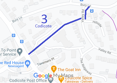
Annotated map reproduced courtesy of Googlemaps.
We need a volunteer to photograph this route for this year's Access and Riding Rights of Way Survey. It's easy - just take photographs (safely) when you use the path. Find out more!
| Paths Greenways Bridleways Tracks | ||
| PG: OBJECTS: PROMOTION: Codicote 3 | ||
Annotated map reproduced courtesy of Googlemaps. |
This route runs from the High Street to Valley Road, and then to Bury Lane.
We need a volunteer to photograph this route for this year's Access and Riding Rights of Way Survey. It's easy - just take photographs (safely) when you use the path. Find out more! |
| Legal History 1 Nov 1953: Recorded as a bridleway on the original (1953) definitive statement. DM sheet DM4-42. 30 Jan 1970: The Hertfordshire County Council (BR.3 Codicote) Public Path Diversion Order 1970 was made. 13 Feb 1970: London Gazette announcement of making the order. The bridleway has been the subject of a diversion order at some point between 1953 and 2015. |
Definitive Statement (4 Dec 2015)
Path: [Codicote] 3. Status: Bridleway. Definitive Map sheet: 43 Commences from High Street adjacent to 'Bell Inn' thence NE to join Valley Road just S of Bury Lane. Continues on E side of Valley Road at TL 2168 1839 thence generally N on eastern verge of Valley Road to Bury Lane at TL 2169 1842. Width: Minimum 5 feet (1.52m) between TL 2163 1837 and its junction with Bury Road. |
© 2022 Patchetts Green Bridleways Trust.
