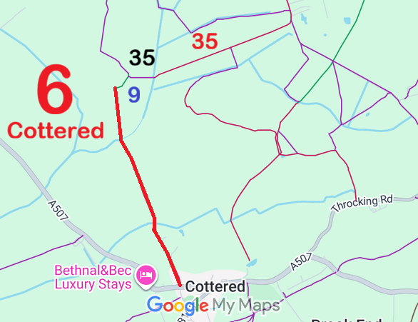
Annotated map reproduced courtesy of Googlemaps.
A volunteer has photographed this route for the Access and Riding Rights of Way Survey, and the page will be updated shortly. Find out more!
| Paths Greenways Bridleways Tracks | ||
| PG: OBJECTS: PROMOTION: Cottered 6 RB | ||
Annotated map reproduced courtesy of Googlemaps. |
Cottered 6 is a restricted byway running from the A507 in Cottered (public road) generally northwards to
Rushden and Wallington 9 bridleway at the parish boundary.
A volunteer has photographed this route for the Access and Riding Rights of Way Survey, and the page will be updated shortly. Find out more! |
| Legal History 2 Feb 1953: Cottered 6 was recorded as CRB (Carriage Road used as a Bridleway) on the original definitive statement. DM sheet DM1-02 (Herts 8 SE) and DM1-07 (Herts 13 NE). 31 Dec 1977: Cottered 6 was shown as bridleway on the special review draft map and statement. There must have been an objection as it remained recorded as a RUPP. DM sheets SR-14 (TL33SW) and SR-23 (TL32NW). 2 May 2006: Restricted Byway rights were confirmed or created on Cottered 6 by virtue of ss 47 and 48 Countryside and Rights of Way Act 2000. |
Definitive Statement (4 Dec 2015)
Path: [Cottered] 6. Status: Restricted Byway. Definitive Map sheet: 14 and 23 Commences from county road N of Church, thence NW along Green Lane to beyond Stocking Hill thence to Rushden parish boundary. |
© 2021 Patchetts Green Bridleways Trust.
