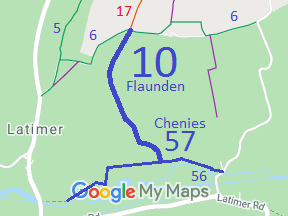
Annotated map reproduced courtesy of Googlemaps.
We need a volunteer to photograph this route for this year's Access and Riding Rights of Way Survey. It's easy - just take photographs (safely) when you use the path. Find out more!
| Paths Greenways Bridleways Tracks | ||
| PG: OBJECTS: PROMOTION: Flaunden 10 | ||
Annotated map reproduced courtesy of Googlemaps. |
The bridleway starts at the junction of
Flaunden 6 bridleway and
Flaunden 17 restricted byway, and runs generally southwestwards and southeastwards through Baldwin's Wood to the county boundary at the edge of the woods. It continues in Buckinghamshire as Chenies 57 bridleway to lead to a junction with Chenies 56 bridleway.
We need a volunteer to photograph this route for this year's Access and Riding Rights of Way Survey. It's easy - just take photographs (safely) when you use the path. Find out more! |
| Legal History 20 Jun 1953: Flaunden 10 was recorded as a bridleway on the original definitive map and statement. DM sheet DM3-35. 31 Dec 1977: The route was shown as a bridleway on the special review draft map and statement. DM sheet SR-82. 19 Dec 1980: The Dacorum District Council (Bridleway No 10 - Flaunden) Public Path Diversion Order 1978 diverted the recorded bridleway. 13 Jan 1981: London Gazette announcement of making the order. The part of the path south of Baldwin's Wood became Chenies 57 BW when the county boundary moved. There has also been a diversion to move Chenies 57 eastwards to its current alignment. |
Definitive Statement (4 Dec 2015)
Path: [Flaunden] 10. Status: Bridleway. Definitive Map sheet: 82 Commences from NE corner of Geary's Plantation at junction with BR6 and RB17 thence SW and SE through Flaunden Grove to Grid Ref: TQ 0101 9895 on the south side of Baldwin's Wood at the county boundary. Width: Approximately 3 metres from Grid Ref: TQ 0101 98995 to Grid Ref: TQ 0116 9681 unspecified elsewhere |
© 2021 Patchetts Green Bridleways Trust.