Paths Greenways Bridleways Tracks
 PG: OBJECTS: PROMOTION: Great Gaddesden 46
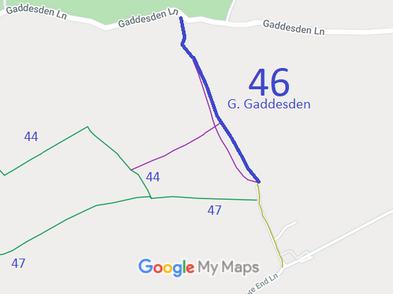
Map showing recorded Great Gaddesden paths
Annotated map reproduced courtesy of Googlemaps.
From Gaddesden Lane generally south-south-east to the public road at Holtsmere End.

We need a volunteer to photograph this route for this year's Access and Riding Rights of Way Survey. It's easy - just take photographs (safely) when you use the path. Find out more!

Legal History
20 Jun 1953: Great Gaddesden 46 was shown as a footpath on the original definitive map and statement. DM sheet DM3-13.
31 Dec 1977: Great Gaddesden 46 was shown as a footpath on the special review draft map and statement. DM sheet SR-54.
8 Oct 1987: The Borough of Dacorum (Footpath Great Gaddesden No. 46) Public Path Modification Order 1987 (confirmed 15 Jan 1988) upgraded the footpath to a bridleway based on user evidence. HCC reference DAC/3.
1 Mar 2002: The 2000 definitive map and statement show the route as a bridleway. Sheet 54.
***
Definitive Statement (4 Dec 2015)
Path: [Great Gaddesden] 46.  Status: Bridleway.  Definitive Map sheet: 54
Commences at junction with county road E of Stagsend (Grid ref TL0742 1188) thence SE along parish boundary towards junction with county road NW of Holtsmere End Farm. (Grid ref TL0767 1133).
Width: 8 ft throughout

The 1988 order recorded minimum width 8ft, not 8ft throughout.

Maintainability
This route is maintainable at the public expense because it was a footpath or bridleway existing before 30 Apr 1959.

© 2025 Patchetts Green Bridleways Trust. File reference: EC1157.

Stats2