Paths Greenways Bridleways Tracks
 PG: OBJECTS: PROMOTION: Hemel Hempstead 132
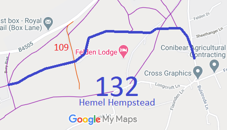
Map showing recorded Hemel Hempstead paths
Annotated map reproduced courtesy of Googlemaps.
This path starts on Felden Lane and heads generally north west then westwards to a junction with Hemel Hempstead 109 restricted byway and on to Bury Rise.
It passes through Sheethanger Common.

We need a volunteer to photograph this route for this year's Access and Riding Rights of Way Survey. It's easy - just take photographs (safely) when you use the path. Find out more!

Legal History
Definitive Statement (4 Dec 2015)
Path: [Hemel Hempstead] 132.  Status: Bridleway  Definitive Map sheets: 65 and 74
Commences from Felden Lane NW along a well defined track thence westwards following southern boundary of golf course, thence SW across the junction of 109 through Bury Wood to junction with FP's 18, 110, and 111 and FP20.

© 2023 Patchetts Green Bridleways Trust.

Stats2