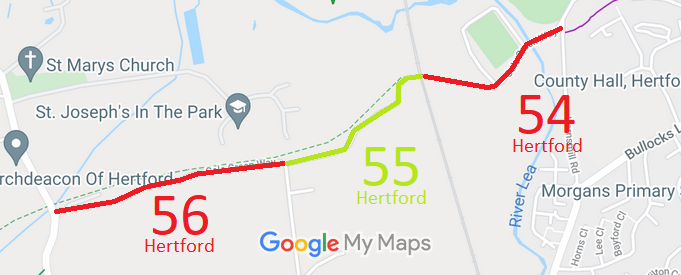
Annotated map reproduced courtesy of Googlemaps.
We need a volunteer to photograph this route for this year's Access and Riding Rights of Way Survey. It's easy - just take photographs (safely) when you use the path. Find out more!
| Paths Greenways Bridleways Tracks | ||
| PG: OBJECTS: PROMOTION: Hertford 54 BOAT | ||
| Cole Green Way: Westwards: Hertford CGW6. Eastwards: Ends (for horse riders) on West Street. | CGW | |
Annotated map reproduced courtesy of Googlemaps. |
This route is recorded as a byway open to all traffic. It runs from the former Hertingfordbury Station, from
Part 6 of the Cole Green Way to West Street (public road).
We need a volunteer to photograph this route for this year's Access and Riding Rights of Way Survey. It's easy - just take photographs (safely) when you use the path. Find out more! |
| Legal History 2 Feb 1953: The route was recorded as CRF (Carriage Road used as a Footpath) on the original definitive map and statement. DM sheet DM2-23 (Herts 29 SE). 31 Dec 1977: The route was shown as a byway on the special review draft map and statement. DM sheet SR-59 (TL31SW). |
Definitive Statement (4 Dec 2015)
Path: [Hertford] 54. Status: Byway Open to All Traffic. Definitive Map sheet: 59 To Hertingfordbury Railway Station. Starts in West Street opposite Wallfields Alley down slope between hedgerows bounding allotment gardens and tennis courts, across wooden bridge over River Lee, through double oak gate, past Lodge, and follows hedge at southern side of Hertford Town Football Club through gate where path curves round following line of barbed wire fence under viaduct. |
© 2024 Patchetts Green Bridleways Trust.
